"Due to Bermuda's excellent geographical location, it was believed
that a HFDF facility built on her soil could fill a critical gap in the
expanding RCN-USN Atlantic HFDF network. However, the Bermuda government
had reservations on allowing the Americans who were already occupying Bermuda
land to acquire more. Instead, after many negotiations, the Bermuda government
gave the necessary permission for the Royal Canadian Navy to establish
a receiving site located at Daniel's Head Somerset, with a transmitter
at Ireland Island Bermuda. Both locations being part of a British Royal
Navy Wireless Station that operated between 1939-49.
The site was activated on a one year trial basis as of 3 July
1963. The initial complement comprised of one officer, and fourteen men,
unaccompanied; with the USN providing accommodation. Over the course of
less than a year, the site proved to be a success, thus becoming a permanent
station on 1 April 1964".
Extracts from the "Bermuda Base Development File" [3] held by the C&E
Museum provide additional information about the base.
"The land and buildings were leased from the Bermuda Crown Lands Corporation
under a 21 year lease signed on 1 January, 1963. Under the terms of the
lease, the Corporation was responsible for the maintenance and repair
of building exteriors, major structural repairs, maintaining roadways,
sewage disposal facilities, water supply systems and plumbing systems except
sanitary fixtures. The property rental was £6000 per annum[5].
Renovations to existing buildings and the erection of receiving and
transmitting antennae masts commenced in 1963 and was completed in 1965.
Installation of a permanent HFDF antennae system began in 1963 by
levelling the area known as "The Head". This leveling work was completed
in September of the same year. Installation of the antennae system commenced
in 1965 and was completed in March 1966. While waiting
for the permanent antenna to be completed the station used a borrowed
AN/TRD-4 HFDF shelter.
Shortly after the work of levelling the pad was completed at Daniel's
head, erosion began eating into the east and north east perimeter
of the pad. Repairs to the eroded sections were completed in February 1966
and were accomplished by filling the eroded sections with rip-rap [1] and
covering it with top soil sowed with grass seed.
In order to improve habitability and appearance of the station, contracts
were awarded for the removal of old concrete antenna pedestals, dead trees,
the cutback of overgrowths of shrubbery grass and weeds. That work was
completed in March 1966.
Rainwater, caught on the roofs of buildings and one large concrete water
catch, provided potable water for the base. It was stored in one large
underground water tank and fed to the buildings via electric pressure systems.
Stored water was tested monthly and chlorine was added only if necessary
since there was no system for routine chlorination. Sewage disposal was
accomplished with septic tanks.
Electrical power for both the transmitting and receiving sites was supplied
by the Bermuda Electric Light Company which generates power with diesel
generators. Emergency power was available at the receiving site but
for the Operations Building only. Power was provisioned by an 18 KVA diesel
generator. There was no emergency power for the transmitting site.
Receiving Site
The receiving site, at Daniel's Head, overlooked the Atlantic ocean
to the north was located approximately half a mile from the village
of Somerset and 11 miles from the City of Hamilton. It was divided into
two sections by a public road which lead to a public beach. The western
section contained the Operations buildings while the eastern section had
the accommodations facilities. The southern perimeter of the site bordered
on a dairy farm which occupied the remainder of the former Royal Navy property.
Residential property surrounded the remainder of the base. This site
was activated on a trial basis on July 3, 1963 and accepted as a permanent
station on April 1, 1964.
At the receiving site, the following buildings were in evidence:
(i) Operations Building - This building housed the operational electronic
equipment and administrative offices. A new Operations/Stores building,
was planned for occupancy by July 1966. The old Operations
Building would then be used for Administrative Offices.
(ii) Technical Workshop - In spite of it being an old wooden building
in poor condition, it was nonetheless used as a place for repairing
and maintaining electronic equipment. Once the new Operations Building
was completed, electronics maintenance was moved there and the old building
demolished.
(iii) Stores Building - This building housed all general and some provisions
stores plus offices for the stores personnel. It was also an old wooden
building in poor condition which was destroyed when the new Stores building
was completed.
(iv) Office-in-Charge Residence - This building was constructed in 1940
but was in very good condition.
(v) Barracks Block - This could accommodate a maximum of sixteen men
and two Petty Officers.
(vi) Mess and Recreation Building - It contained a galley , dining room
plus a bar and lounge. The building was in basically good condition but
need some work.
(vii) Miscellaneous Buildings - There were four smaller buildings used
for storage.
 |
WWII era (?) Bermuda W/T site plan.
Click to enlarge. This is believed to be a Royal Navy site plan from perhaps
from the WWII period since they occupied the base from 1939-1949. The RCN
would not be using the term "W/T Station" to title a drawing for
a SIGINT station in 1963. Note the array of concrete pads with masts situated
on bearings 060 and 080 true. When Canadians came to Daniel's Head,
the concrete pads were not in the way of anything because the AN/GRD-6
arrays were situated by the beach. These pads were ripped out by 1966.
Although this drawing is of poor quality, as much information as possible
has been rendered from this site plan. The original file is believed to
be held by the C&E Museum, Kingston. (Submitted by Bill Robinson) |
Transmitting Site
The transmitting site on Ireland Island, was located approximately
3 miles north east of the receiving site. It overlooked the Atlantic Ocean
to the northwest and occupied a portion of the former Royal Navy dockyard
known as the "Keepyard". That area consisted of a large number
of abandoned buildings. Bermuda's Canadian transmitter was housed in the
same building that the Royal Navy used for their transmitting gear but
the anternna was within the boundary of the "Keep". It was a 10 Kw
HF SSB transmitter.
At the transmitting site, the following buildings were in evidence:
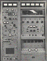
(i) Transmitter Building - This building housed two RCN transmitters
with facilities to expand to perhaps four transmitters.
(ii) Generator Building - This building, which formerly housed diesel
generator equipment for the Royal Navy, was not in use during the mid 1960's.
The walls and foundation were in good condition but the doors and windows
needed replacement.
(iii) Storage Building - In the 1960's , this building was not in use
and it could not be determined what the Royal Navy used it for. It may
have been used as a storage building".
Chief C.H. Tupper served in Bermuda. His son, C.D. Tupper provides some
additional details about the transmitting antenna. "The actual transmitter
antenna was in the Keep -at the very end of Ireland Island. The whole
area around the antenna was fenced off and a warning light was placed there.
As well, the sea area was also marked with buoys and big warning signs.
To get into the Keep my father had to stop and pick up the keys at the
Freeport duty free zone entry. It was a two key set consisting of massive
old key and a second smaller one. The big one, about a foot long,
as well as the smaller one were used to unlock the gate to The Keep. My
father had to make checks in The Keep on a daily basis.
There was once incident where sheep died in the vicinity of the transmitting
antenna. Once a week the Navy would shut off the transmitter
so the local farmer could let the sheep in into the antenna field to graze
on the grass. The exact cause of the sheep's death was never determined
but it was likely by electrocution. However, the Navy compensated the
farmer for his loss."
 |
| This print depicting CFS Bermuda is available from the Communications
and Electronics Museum in Kingston. (C&E Image) |
RADIO OPERATIONS
In 1950, the RCN and the USN formally agreed to coordinate and standardize
HF/DF activities ashore. Jointly, it was called the Atlantic HF/DF
Network. This initiative resulted in the integration of all Canadian and
US stations into two networks which would provide mutual support for the
common objective of maritime warfare. The two networks were comprised of
five RCN stations: Coverdale, NB; Chimo (1949-52), Frobisher Bay, N.W.T
(1952-1966).; Gander, Nfld; Bermuda (1963-1993), Gloucester, Ont. and nine
USN stations. On the west coast, that arm of the Net was called the Eastern
Pacific Network and consisted of one RCN station at Masset, British Columbia
and eight USN stations.
Coverdale was also designated as the Alternate Net Control station for
the Atlantic Network. The primary Atlantic Net Control station was located
at Cheltenham, Maryland. In actual practice, Coverdale performed this function
about 25% of the time just to keep the operation up and ready.
Ray White provides a table outling the membership of the Atlantic HFDF
net in 1954. Stations marked with an asterisk joined the net at
later dates as indicated.
Notes for this table:
[1] This site was part of the Bullseye project and employed CDAA technology.
It did not become a net member until the 1960's.
[2] The DF function of Balboa closed in 1940 and moved to Toro Point.
The latter site closed December 1952 and operations were moved to Galeta
Island, Panama. Galeta became fully operational as a CDAA site on 23 Oct
1965. It finally closed on 31 March 1995.
[3] Frobisher Bay and Recife Brazil were the most problematic stations
from the viewpoint of HF communications. Often they could copy each other
but none of the stations in between heard them.
[4] Coverdale's call sign was changed from CGT to CKT because many operators
slurred the Morse characters of the call CGT and it came out sounding like
CQ.
[5] Gloucester was an operational part of the Atlantic HFDF net in 1951
even though it primary function became that of a training school in 1948.
As time marched on, participation in the net was very sporadic and was
only for training purposes.
[6] This was the call sign indicated in the NSG website but was not
the call sign that this station used when communicating with the Atlantic
HFDF net. The call signs that were actually used cannot be confirmed at
this time but are believed to be: Amagansett - NAH; Winter Harbour - NAA
and Homestead - unknown.
Keith Forbes Bermuda web site provides information about Bermuda's debut
in the SUPRAD system.
"On July 4, 1963 the station became operational. It was ready
on July 1 but it was not invited to join the American-led Atlantic HFDF
Network until this date to coincide with US Independence Day ceremonies.
The Atlantic Net Control at Cheltenham, Maryland, or Alternate Net Control
at Coverdale, New Brunswick, originated flash
directives which were picked up on frequencies by the net's outstations.
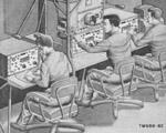
The received flashes were decoded, targets searched and target bearings
observed, then encoded and reported to Net Control, either by HF radio
or landline. The station's DF unit consisted of a loaned AN/TRD-4
HFDF shelter sited about 450 feet northwest of the Operations Building
at Daniel's Head. It was operated for a few weeks on auxiliary power while
awaiting shore power installation.
By August 1963, the effectiveness of this station's operations was such
that it soon became obvious that Bermuda was to stay. It had passed its
probationary period with flying colours. But the opposite was experienced
at Frobisher Bay. That station subsequently closed down as a direct result
Bermuda's proficiency. It had delivered its mission - to effectively provide
cut-off bearing for accurate fixes on transmitting targets."
Norm Paine was drafted to Bermuda in June 1965 while he was
a P1RS4 (291'er). He recalls. "When I arrived in Bermuda, station strength
was about 23 personnel under a Commanding Officer, a station CPO and myself
as a P1RS4 Operations Supervisor. We had about 14 (291'ers) 3 technicians,
2 RCN cooks and 1 naval storesman.
When approaching the station two buildings became evident. One was the
Singles quarters and the other longer one was the galley/dining area
and a decent size lounge/bar for the troops. About 150 yards up the hill
was an older building that was Operations. At one end there was the CO's
office with secretary (a local gal) then the CPO's office. My office was
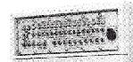
adjacent to the Ops Room/DF area which contained the AN/GRD-6 DF set.
Because Bermuda did not have sufficient space to install the high and
low band DF arrays with adequate separation, a decision was made to
combine both arrays into one field. The inner circle was the high band
array, while the outer circle was the low band array. This configuration
was tested by the USN around 1963 and because the design worked well, that's
the way the station operated when I arrived in 1965. After I left,
the station complement was increased to around 40 personnel".
By 1969 new and improved equipment in support of wideband operations
was installed. In September 1979, operations was shut down for two
months for the removal of old antenna and the installation of a new Pusher
system. Bermuda once again became operational by November of that year.
In 1968, the Control and Alternate Net Control stations of the Atlantic
HFDF started to change. This table, provided by Joe Glockner, summaries
the changes. When Coverdale closed, it handed over its Alternate Net Control
function to Skaggs Island CA which was also the Alternate Net Control for
the PAC Eastern HFDF net.
| LOCATION |
FUNCTION |
CALL SIGN |
COMMENT |
|
|
|
|
| Cheltenham, MD |
NCO |
NSS |
NCO till 1968 |
| Northwest, VA |
NCO |
NAM |
NCO from 1968 |
| Coverdale, NS |
ANCO |
CKT |
Until 1971 |
| Skaggs Island, CA |
ANCO |
NPG |
ANCO from 1971 |
NCO = Net Control
ANCO =Alternate Net Control
AMATEUR RADIO
Harry Billard , currently holding call sign VE7JH, operated amateur
station VP9HH while he was stationed in Bermuda between 1973 and
1974. This was not a club call sign but one he procured for himself in
order to run phone patches. He operated Collins type equipment into big
beams which he set up at his own expense.
Scott, now VA3XA, operated the club station VP9CB (and was also its
President) from 1990-93 using his personal call VP9MM. During
that time, he made about a quarter million radio contacts under VP9MM
which required the services of a QSL manager. Whenever Scott visits Bermuda
he still uses VP9MM.
CLOSURE
The base closed on July 4, 1993 and the lease on the land and buildings
terminated on December 31, 1993. Nothing remains of it today. In
2000, the Daniel's Head Village Hotel opened on the site, but has since
closed due to economic reasons. The former station is now the Daniel's
Head Beach Park.
Bill Robinson posted a story about a Bermuda stamp which salutes the
station in his Lux Ex Umbra Blog dated September 7, 2005.
"I'm no philatelist and I wouldn't think of dispensing philatelic
advice. But I'm guessing that CFS Bermuda is the only HF-DF station featured
on a postage stamp, given that information about such places used to be
more typically mailed on microdots.
Issued by the Bermudan government in 1996 as part of a set commemorating
former Second World War and post-war bases in Bermuda, the CFS Bermuda
stamp shows the Canadian Forces symbol, some generic looking antenna masts,
and Canadian personnel at work in the operations room. The actual HFDF
array is not depicted. [4] NRS/CFS Bermuda operated from 1963 until
1993, providing cut-off bearings on Soviet missile submarine transmissions
and other maritime targets.
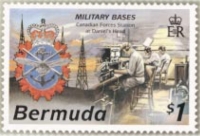 |
| Image courtesy Lux Ex Umbra Blog. |
Interestingly, the Bermuda HF-DF station was not the only Cold
War-era naval SIGINT system immortalized by its own postage stamp. The
U.S. Navy's WHITE CLOUD ocean surveillance satellite system, first launched
in 1976, was actually shown in some detail on a U.S. stamp issued that
year. If I remember the story correctly, the stamp was withdrawn from sale
rather quickly".