 |
|
INTRODUCTION
It commissioned as HMC NRS and remained that way from 1 Dec 1950 to July 1956. From July 1956 to July 1966 the station became HMCS Churchill then changing to CFS Churchill in July 1966 until the station closed in 1968. The nearby town of Churchill is acknowledged to be the polar bear capital of the world. |
HISTORY OF CHURCHILL
The first Europeans to sail across the bay reached the Churchill area in the early 17th century, ostensibly in search of the fabled northwest passage. Half a century later, European interest was rekindled in Hudson Bay with the granting of a royal charter to the Governor and Company of Adventurers of England Trading into Hudson Bay (the Hudson s Bay Company), but these adventurers were not after the silks and spices of the Orient, but the lush fur pelts of the region inland from the bay of the north sea.
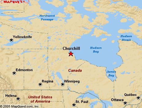
Churchill is located at latitude 58° 43' 30" N and longitude 94° 07' 00" W, on the western side of Hudson Bay about 1,169 km away from Winnipeg, Manitoba. (Map courtesy of Mapquest.com) Although it is not self-evident, Churchill is the closest seaport to the great cereal fields of central Canada. In the 1900's, it was decided that a port would be constructed on Hudson Bay and Churchill was chosen as the site. In 1930, a railroad was built to link Churchill to the grain elevators in southern Manitoba some 1,900 kms distant.
In 1946 the strategic significance of Canada's north in the defence of Canada was realized. Exercise Muskox was the first of a decade of annual northern exercises to develop Arctic knowledge, develop tactical doctrine and test communications in the far north. Exercise Muskox consisted of a 2,900 mile motorized Arctic trek commencing in mid February 1946. The party started at Fort Churchill and visited Eskimo Point, Baker Lake, Perry River, Cambridge Bay, Coppermine, Port Radium, Fort Norman, Fort Simpson, Fort Nelson and Edmonton. At Cambridge Bay they visited with RCMP Inspector Larsen and the St Roch, the vessel which made the first successful voyage through the North-West Passage. The party arrived in Edmonton on 6 May 1946, only one day behind schedule.
In 1950-51 Exercise Sundog II involved movement of material in the Fort Churchill area. RCSIGS (Royal Canadian Signals) average time to move 100 miles was 12 hours versus the 12 days that other units took with their tractor trains, proving the effectiveness of light equipment developed in earlier exercises. Exercises in 1951-52 were also major endurance tests involving minimal vehicles and three month deployments for the 37 signalmen involved.
STATION HISTORY AND DESCRIPTION
Original documents located in the National Archives suggest that the National Research Council (NRC) had a special W/T station set up on behalf of the RCN in a storage hut owned by the National Harbours Board (NHB). It is further believed that this was the beginning of the station which started operations on August 1, 1943. By September 9, 1944, the entire operation was officially handed over to the RCN by authority of Captain R.J. Morgan, the Deputy -Secretary of the Naval Board. The navy was granted the use of a building and a strip of land to erect an aerial by the National Harbours Board (NHB) for the duration of the war. In addition, the navy also assumed control of whatever equipment and staff was provisioned by the NRC3.. The facilities loaned to the Navy were referred to as the "retail store" in their loan agreement with NHB This agreement provisioned free rental for the duration of the war and it was for the purposes of operating a wireless station.
Following the war, Churchill was demobilized until the RCN could raise funding for additional expansion to the Churchill location. The station reopened as NRS Churchill and continued operations at the Harbours Board warehouse. It was a joint project of Communications Research (a civilian organization) and the Navy to develop ionospheric data for the propagation of radio signals at northern latitudes. In a later development, Churchill provided HFDF services with an additional 40 communications research personnel on staff.
Hjalmar Hansen was there when NRS Churchill was reactivated. "Lou Henry, two carpenters and myself started the ionosphere station. It was set up out at the very end of the railway in part of a National Harbours Board warehouse. The Naval Radio Station was located on level ground alongside the rail spur which serviced the grain elevator. We boarded in the Harbours Board summer quarters until accommodations were completed in the warehouse and we continued eating most of our meals there then too. Mabel Reid made the best clam chowder and French toast. The ancillary equipment such as poles, antennae, all the "stuff" that finally comprised operations came with a lot of assembly required but the transmitter and Ops Room gear came as complete ready to operate units.
I remember Ross Freeman of the National Research Council, Bob Vancamp RCNVR and ex-Hudson Bay agent, Jim Brooks RCNVR, Alex Laurie -Tech RCNVR, Chief Barry RCN, and CPO Trickett - technician RCN. Chief Art Little-RCN was the CO when I was drafted out of there after serving four and a half years. Lieut. Jack Meek discovered my long stay thus initiating the draft. Other names I remember are Jim Woods, Loughland Laurie, Harry Atchener, Alf Harrington and Bill Amos. Bill was famous for his Boston cream pie. One notable character was a French-Canadian lad who wore those big black horned rimmed glasses and on occassion, would like to excite his body by running outside and jumping into the snowbank. We used to commandeer the railway section gangs gas car and trailer to go down the line and get ourselves a caribou when they were migrating through Churchill.
During my time there, we studied the aurora borealis and had to make hourly reports on type, intensity, duration etc. We used a little smoked glass device calibrated to determine intensity. Taft Davies, "Dr.Taffy" as we called him, was a physicist who had once accompanied Admiral Byrd to the Antarctic and was immensely interested in our product. We also did some research on the relatively new mode of Frequency Modulation one summer. Chief Barry was in charge of that project - he was one real tough old salt. There was the monthly chore of totalling all of our recordings sent to Ottawa and they had to balance for some reason or another which I cannot recall. While at Churchill I operated as VE4MQ and used equipment found in an army mobile unit".
It seems the RCN did not turn the property back over to the NHB after the war and it wasn't until September 1949 that the Manager of NHB decided that they should start collecting rent ( $100/month) on the property since they were in business to make a profit. The RCN quickly turned over the ionospheric research facility to DOT in October 1949 under the authorization of Lt.(N) John G. Waters.
After the war, the RCN wanted to erect a rhombic antenna over the railway land but this was deemed unacceptable for reception so a search was started for a more suitable location. By 1947, Churchill was a tender to BYTOWN (Ottawa). Due to increases in personnel, Churchill , along with Coverdale and Gloucester were designated to become Fleet Establishments in 1949. Only Coverdale and Gloucester commissioned that year. Churchill had to wait. As a tender, there was no official badge until the station commissioned.
As interest in Churchill continued to grow, a requirement for three rhombic arrays of nine antennae each was defined. DND approached NHB in order to acquire a some of their properly at a site referred to as the East Peninsula. Two parcels of land transferred control on June 15,1948. This eventually became part of the site that we all know today.
Click to Enlarge
Pre 1949: This was the location of NRS Churchill while the station was reactivated in 1948 and located at the National Harbours Board warehouse. The radio station was near the end of the railway spur and the rails were almost as high as the roof line of the station. (National Archives drawing submitted by Joe Costello) 1949 Station Plan: The area crosshatched in red were two parcels of land originally proposed for the new Churchill station site. Due to limitations explained in the text, DND also requisitioned a third parcel which is shown in green crosshatch. Note the rail line front of the building and the old hospital site at the right side which became an Indian village later on. The three rhombic arrays were not installed exactly as shown on this drawing. Out of view at the left most side is a rectangle labelled "transmitter building". It is not confirmed if this was Churchill's transmitting site although the area was bristling with masts as evidenced in a 1965 aerial photo. (National Archives drawing submitted by Joe Costello) 1950: Key buildings are identified in this hand drawn sketch from the book "Churchill North of 58". The sketch confirms the location of the original ionospheric research station. (From the collection of Doug Stewart) The land offered by the NHB was certainly adequate to accommodate three arrays but there were two major problems. The Hudson Bay Railway intersected the property and the concern was that passing trains would produce interference. Not only that, one array would have to be so distant from the Operations building that the cost of the interconnecting coax cable would be prohibitive. Another proposal was sent to the NHB in which DND requested the parcel of land directly across the road from the current site of the Operations Building. This caused great concern for NHB because that area was a natural watershed and also held an area water reservoir, presumably for the town of Churchill. DND assured NHB that the utmost care would be taken so as not to pollute the land during the construction phase. Deliberations over this parcel of land continued, however, by January 15, 1949 the third parcel of land changed control and DND now held all three parcels4.. It is presumed that construction of the Operations Building started in that year, and likely before the RCN turned over control of its NHB rental property to DOT. The contract negotiated with NHB also stipulated that the land would revert back to their control once it was no longer needed by DND.
This was the location of HMCS Churchill relative to the Town of Churchill. (Map courtesy Google Earth) When the DEW was under construction in the 1950's, NRS Churchill's airport became an important way point for aircraft ferrying supplies to the DEW line stations. A second auxiliary location was established for the station, but it sat unused since it was very difficult to access the site in winter.
There was lots of confusion when people said the 'base' because the NRS was often called the navy base or just plain base. The Army and Air Force people referred to Fort Churchill as the base or the camp. Aside from the presence of the white ensign at the NRS, there was no real indication that this was a military installation. Churchill comprised of the following areas:
a) the Prince of Wales Fort on the other side of the Churchill River.
b) the town of Churchill with it's assortment of buildings and the Grain Harbours Board.
c) the Naval base known as NRS/HMCS/CFS Churchill.
d) the combined Canadian Army/US Army base called Fort Churchill which included the airport
e) the rocket range some distance away.
f) some settlements for the natives which were known as Camp 10 and Camp 20 for a while.
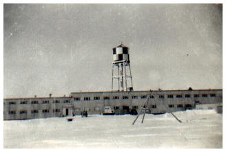
1961: The water tower behind the 'T' shaped Operations Building was an unmistakable landmark on the Churchill skyline. (Photo by David Smith) Ray White who served at HMCS Churchill in 1952-54 provides a description of the base. "In my day, there was the main, T-shaped Operations Building with the HFDF shack located about a mile away. The road to this shack followed a sewage-disposal line for much of its length and then veered off towards the HFDF shack, the conventional low-slung structure with an Adcock antenna array in near proximity. In front of the Operations Building was a large garage-type building.
In addition, there was a small outbuilding near the emergency exit of the Operations wing. This was used for the routine burning of classified waste, a process that took place on an almost constant basis. This flimsy, plywood building was destroyed by fire several times during my stay in Churchill when the incinerator operation got out of hand.
Electricity to the base was supplied from the local power grid, which was referred to as shore power by station personnel. In the event of a power interruption a diesel-electric generator could provide emergency power. I did not recall many power outages during my stay.
Across the road from the base was a small sports field which was not over-used, generally because when the weather was warm enough for a softball game, it was also warm enough for the bugs".
RADIO OPERATIONS
Churchill was part of the SUPRAD (Supplementary Radio) network. In the beginning, it had vastly greater operational functions than stations such as Aklavik, Chimo or Frobisher who were confined to HF/DF operations. Churchill was a much larger establishment but basically they were just like Coverdale on the operations side but without the heavy involvement in HF/DF network operations. Churchill was not part of any DF net, however it was used to aid in identifying sources of radio transmissions.
In its heyday, Churchill was the largest intercept station that Canada had. There were perhaps 15 or 20 operators on a watch and in 1954 the first WRENS to serve in the North were sent to Churchill.
The station was connected to DSRA in Naval Headquarters in Ottawa (DSRA the Directorate of Supplementary Radio Activities) by commercial landline, a 60-WPM circuit operated by CN Telegraphs. Most operational traffic was relayed by NSHQ to CBNRC [1]. Administrative traffic for other than SUPRAD addressees was handled by the RCNs trans-Canada communication circuits. All SUPRAD stations had circuits connecting them to NSHQ (DSRA).
In May 1953, the Minister of Resources and Development had submitted a recommendation from the Advisory Committee on Northern Development that the radio station at Padloping Island, NWT be taken over from US control. It was first used as a weather station by the U.S. Coast Guard until the end of WWII.
The Cabinet approved the recommendation. It stated that the Royal Canadian Navy be authorized to take over the operation of Padloping Island radio station from the United States, as soon as practical, for a two year period until the Department of Transport (DOT) was in a position to provide staff for its operation. The cost of operating the station was to be borne by the DOT.
As a result, weather station VFU8 was established on Padloping. Since the DOT could not fulfill the original intention of manning it, VFU8 did not attempt communications with CFH (Halifax) but only sent its weather observations to VFF (DOT, Frobisher). All RCN administrative traffic with Padloping was passed through CFL (Churchill) and, occasionally, through CFI (Frobisher) when radio conditions were disrupted by ionospheric storms. Although it was commonly referred to as NRS Padloping Island, it was still a DOT weather station with the only RCN connection being the personnel and the administrative communications through RCN channels. The five radio rates at Padloping were Communicator Radio. "Operations were abandoned at Padloping by 1956 [5] .
For a look at life at Padloping Island in 1953, select this link.
Padloping Island, originally an Inuit community, is now part of Nunavut Territory. It is situated in Merchants Bay off Davis Strait at 67°3'N 62°45'W. The island is 6 km long and 2 km wide and was previously the site of the USAF Crystal III air base during WWII. (Map courtesy of Multipmap.com) From mid-June to the end of September 1955, HMCS Labrador (icebreaker) served as the senior ship of a task group of 14 ships, including USN and US Coast Guard Ice Breakers, charged with the delivery of thousands of tons of supplies for the joint US/Canada Distant Early Warning (DEW) Line sites in the Foxe Basin area of the eastern Arctic. Because of the very poor communications conditions in the northern latitudes, Churchill was assigned ship/shore/ship responsibilities during her summer deployments as a secondary responsibility.
This short account appeared in the November 1956 edition of Crowsnest Magazine.
CHURCHILL DEFIES POOR RECEPTION
Poor radio conditions, attributed to sunspot activity, dogged HMCS Labrador during her 1956 mission in the waters of the Canadian Eastern Arctic. Not only did the Labrador and the U.S. ships serving with her find it hard to read the signals from other ships and shore stations, but the shore stations found it hard to untangle ships messages from the atmospherics. One shore station which stolidly settled down and dealt with this tangled traffic was HMCS Churchill, the naval radio station at Churchill, Manitoba.WATCHKEEPINGChurchill, among all the shore stations handling traffic to Task Force 6 in the eastern Arctic, was singled out by Rear-Admiral R. Mason, commander of the task force, who said Churchill had always shown a readiness to put forth the extra effort required to receive and relay weak signals.
Admiral Mason said task group commanders had praised most highly the services rendered by Churchill.
During the period 1952-54, the watchkeeping system at Churchill was three 8-hour dog watches (1600-2359), three 8-hour middle watches (0001-0800) and three day watches (0800-1600) followed by 72 hours off. There was no relaxation of this schedule. It was maintained during holiday periods and long weekends. Complete watches were on duty at all times. During periods of inclement weather, for example, which might delay arrival of married personnel coming on watch from their PMQs (Permanent Married Quarters) in Fort Churchill, those being relieved would be required to remain on duty.
WRENS
In November 1953, the first WRENS to serve in northern Canada arrived at Churchill. They were Sub-Lieut Barbara Schmidt - Kingsman Alberta; WRENS Lorraine Brown - Swan River, Manitoba; June Buchanan - Napanee, Ont; Phyllis Chandler - Pinewood , Ont; Noni Hag - Vancouver; Betty Jean Clayton - Medicine Hat, Alberta; Doreen Patterson - Vancouver; Betty Rivers - Edmonton ; Billie Totten - Windsor, Ont. and Lilly Arnold - Willowdale Ont. In that era, the town of Churchill consisted of a Hudson's Bay Store, a theatre, two hotels and a few small clothing stores.
The Wrens were provided accommodation in the single women's block which was used by teachers, nurses and various single women employed in Fort Churchill. This block, which was called F6, was connected to the Army Officers Mess. Wrens were billeted two to a room. When they were on duty the women had their meals at the Navy base. When off-duty, they ate at the Army Officers Mess, even though the average rank was Able Wren, the equivalent of an army private. There were also facilities in a small common kitchen for the preparation of snacks. Because of the presence of a small number of young, single females in this very large male army camp, there was a requirement for some element of separation. There may have been perhaps 25 women on base and upwards of 2000 men at times.
Wren's functions were identical to the other CS rates. Some operated high speed morse positions, some were on manual morse positions. They did transcribing and, as well, worked in the cryptocentre and the landline circuits to Ottawa. Since the Wrens quarters were in Fort Churchill, they were shuttled between the fort and the navy base, in a 4x4 fitted as a station wagon. When weather was bad, the practice was to use the Army Service Corps transportation company, who provided Penguin tracked vehicles in rough weather.
Irene (nee Lowen) Whalley did not arrive until January 1954. She was the first Wren to stay in after getting married in Ottawa on 9 October 1953. For the first couple of months she roomed with the Wrens and other single girls in F-6 (within the Army base), while her husband Terry lived onboard with the single hands. It was not the best way to start married life.
Douglas Stewart, a CS rate who served at Churchill, remembers the Wrens. "When I arrived Churchill 1954 there were approximately 25 WRENS and by the time I left in 1956 they too, had pretty much all gone. Some married while posted in Churchill. Their Divisional Officer at that time was Lt Rennie. During the early 1960's SUPRAD ceased recruiting the girls since they were considered unsuitable to isolated stations and those still posted were allowed options for trade remuster. Several elected release, while others became "Sparkers" serving at Albro Lake"
RECEIVING FACILITIES
Ray White provides this glimpse into the radio operations at Churchill. " On the Upper Deck of the base building, was the main operations room. In my day, 1952-54, part of the area was the tape transcribing section, where operators would transform high speed Morse material into text for analysis and onward transmission.
Against one of the walls, were the High-Speed positions. These consisted of rack mounted pairs of receivers together with McElroy or Mechanitron undulators [2]. When a high speed CW target station came on the air, it initiated communications using manual CW. Once signal strength information was exchanged with the "other end", the station with traffic would send 'revs' or reversals of polarity. This was, in effect, a stream of (letter) E's sent at very high speed. After that, the traffic transmission started and it could go on many hours at a time. All traffic was all recorded using ink strip tape recorders. Surprisingly, there were very few cases of reversed polarity. The receiving operators were so accustomed to this stuff, that they flipped the switch shortly after the recording session began."
David Smith, who served in Churchill in 1960-61, remarks about the ink strip recorders." I can remember having to be very quick off the mark, leaping out of the chair to reach up and flip the recorder on once a transmission started from a target . The speed at which the tape passed under the the recording pen could be varied by a knob. If you had the tape going through too slowly or quickly, you either had a closely spaced trace or a very elongated one, neither of which was appreciated by the transcibers. There were times when it seemed you couldn't crank it up fast enough to handle the transmitting speed.
Sometimes the receiving operator could not adjust for optimum shape of the characters on the ink strip. When this happened, and the transcribing operator found the strip illegible, they would mark it as unreadable in the log and move on. I remember sitting there transcribing this stuff - talk about sore eyes after a few hours. It was however, amazing how fast one could go after a bit of practice."
Doug Stewart comments on a health and safety issue while transcribing. " I did my share of transcribing too, as a new operator. An optometrist came to Churchill to test all personnel. He could not understand why some people had eye muscles pulling the eyes slightly to the right. I could not help but to remember how we tried to read the tape as it came from the reel and before the symbols passed in front of our position".
Ray continues. "In a separate room, which adjoined the operations room, were the circuits which we used to communicate with CFV (Aklavik), CFI (Frobisher) and VFU8 (Padloping Island) using CW and RATT (radioteletype). Near that room, was a windowed area known as the "wheelhouse" where supervisory personnel would be located.
The remainder of the room was dedicated to receiving bays using Hammarlund SP600-JX receivers. Each pair of receivers was positioned on 4 foot by 8 foot table. All these tables were replaced by proper metal operating positions after I left Churchill.
The entire Operations section was secured by a single door controlled by an electronic lock. Everyone who worked in Operations had the security clearance to enter that section. A three or four number combination would unlock the door, allowing access. to the main operations room, the technical workshop, the cryptocentre, the Comcen (communications centre) , and the Ops Officer and Ops Chief's offices. Others, and this included all non-operations personnel, officers and men, who might require occasional access would ring the bell and await an escort. Such personnel would never have access to secure areas - they might, for example, proceed to the Operations Officer's office or the Ops Chief's office. The escort remained with them throughout the visit.
An antenna patch panel was located along another wall in the operations room. These contained banks of antenna multicouplers which permitted a number of receivers to operate with a common antenna if required. There were also BC-221 frequency meter sets associated with the antenna positions. These were required since the SP-600 was notorious for it's inability to display frequencies with more accuracy than +/- 25 kcs.
When an operator wanted to measure a frequency, he would remove his antenna connector from the multicoupler and plug it into the "Meat-waver" - the colloquial term for the BC221 - and get a frequency reading as good as 1 kHz. This was a laborious process, but in the 1950's, and being able to report a frequency as 12416/M was quite a bit better than 12400/X or 12425/X. The 'M' signified measured, while 'X' meant estimated. When the Racal RA-17 receivers came on board, we no longer had to worry about this problem.
The practice in Aklavik, Inuvik, Churchill and Coverdale was to copy manual morse by pencil and paper then transcribe it to fanfold paper on a telegraphic typewriter. Automatic morse sent at manual-level speeds was copied directly on a telegraphic typewriter. In 1964, an entry in the Naval General Orders (NGO's) authorized Churchill to hold 45 telegraphic typewriters".
VLF
In 1952, the US Navy built a VLF transmitting station at Jim Creek, Washington. The purpose of the station, call sign NLK, was to communicate with the submarines of the Pacific fleet. At the time, it was the most powerful transmitter in the world having a power output of 1 megawatt. Ray White recalls the monitoring that was done for the USN at Churchill in 1953.
"The USN provided all the gear we needed for the monitoring period receivers, antennas, recording equipment, charts, the works. We followed a fairly intense testing schedule, copying VLF broadcasts of exceptionally slow morse, on-off keyed (CW) teletype at very very slow baud rates and a number of other signaling systems which I cannot recall. The CW was in the range of 2 or 3 wpm, and the teletype, which we recorded on paper tape, was just as slow. We didn't realize how important this communications system would become as submarines would soon would be spending protracted periods of time at unimaginable depths. The tests lasted about six to nine months if my memory serves me correctly".
For additional information on VLF/ELF communications, see this story.
HFDF Operations
Ray White explains HF/DF operations at the base. "We had a single CNF-4 direction finding set and one Adcock antenna array. We were not part of the Atlantic HFDF net like other SUPRAD stations. Instead, our assignment was to support the operational work being carried out in the main building and, believe it or not, the RCAF's search and rescue operations.
On many occassions, aircraft got themselves into difficult situations and Churchill was called on regularly to provide bearings. In spite of this important work, problems arose because the RCAF did not understand the effect of Churchill's proximity to the magnetic pole and the effects on bearing accuracy. We tried, but just couldn't convince them that it was always possible that we were reporting bearings 180° away from true. Their on-air comments were sometimes quite scathing. One guy actually said "The Navy must be into the rum tonight" and word of it got back to the C.O. who made an official complaint about these unprofessional words. The C.O. of the RCAF at Fort Churchill apologized for the comments made by one of his crew.
HFDF operations were not very successful in Churchill because the bearing deviations always exceeded the standard allowable deviation possibly because of the Aurora Borealis (Northern Lights) and the proximity to magnetic north pole. In spite of the difficulty, HFDF operations persevered for the length of time that I was there".
In April 1953, it was reported that intercepts on low HF circuits, were good in winter but bad in summer. On the Northern
Sea Route, which used MF as well as low HF, it was good. all year round. ( see note 31)TRANSMITTING FACILITIES
Churchill had transmit capability using a Canadian Marconi TH-58 transmitter which co-located with the Army and Air Force transmitters at a site near the main base at Fort Churchill. The station worked Aklavik (NWT) for extensive periods, upwards of 12 to 18 hours at a time using an 850 Hz FSK radioteletype link with traffic sent at 60 wpm. There was a continual stream of traffic, especially from Churchill to Aklavik, but Aklavik also sent all its Rockex traffic on this circuit which was a duplex operation.
Ray White provides some details. "I recall the in's and out's of this circuit because it was my assignment for a considerable period while I served in Churchill. I recall that several operators used Vibroplex speed keys, the use of which, was only approved for those operators who passed a test. But most traffic was not sent in CW; both stations used radioteletype. The FS keyed signal was the Allied standard for HF operation at that time, with frequency shift between Mark and Space being 850 Hz.
To switch from CW to radioteletype mode, we locked the Morse key in the the closed position, then started the tape reader which read an "RY pattern" test tape. It was run until the receiving station reported readability. The RY test tape had hole patterns which were opposite of each other. Sending these two specific characters in sequence ensured that the receiving teletype machines could receive each "bit" in the 5 level Baudot code.
We operated at 60 WPM and the stations had to pay close attention for requests for repetition. One must bear in mind that operation between Arctic stations was always an "iffy" proposition and many such requests for repetition were the norm. During periods of blackout, due to disruption of the ionospheric path , we generally would revert to CW in an attempt to pass high precedence traffic. As everyone knows, CW gets through when most other modes don't make it. It was not uncommon for the circuit to be active for ten or twelve hours at a time, and sometimes it would run for a full day. It should be borne in mind that Rockex is a teletype-based system and all such messages received in CW had to be typed on the Teletype Model 19 we had beside the position. Although I am describing the operation at Churchill, Alkavik had the same equipment setup in the radio room..
DF SERVICES
In early 1961, the RCAF approached the RCN to request that HMCS Churchill provide D/F services to aircraft flown by Operational Units of Air Transport Command. It would be a priority service for emergencies only. Requests for routine D/F bearings in the support or aircrew training would be treated as secondary tasks and performed by Churchill personnel on a non-interfering basis. At the time, there was an RCAF School of Navigation based in Winnipeg. Obtaining D/F bearings was a likely part of student navigator training.
To further support this formal request, the RCAF would install a dedicated telephone line between their airbase in Churchill and HMCS Churchill. It seems strange that it would take until 1961 for the RCAF to formalize a practice that had been in effect since at least 1953-54, yet, there it is in the Churchill archives.
In the past, the RCAF said that Churchill had not been used to maximum advantage because of the delay in obtaining D/F bearing information. This was the procedure that was employed:
a) The aircraft requests a bearing through MACS (Military Aeronautical Communications System) Churchill.
b) The MACS operator instructs the aircraft to standby, phones the RCN and requests the operator to listen on the frequency in use.
c) The MACS operator then instructs the aircraft to transmit so a bearing can be obtained.
e) The MACS operator relays the bearing info to the aircraft.The above procedure in itself caused a delay which could be tolerated but the delay became intolerable when the MACS operator was unable to contact the RCN because of a busy telephone line! A direct line from the MACS operator to the RCN building would solve the problem. This is likely the reason as to why the RCAF approached the Navy in a formal manner to obtain D/F fixes.
Ray White recalls some operational aspects from this period." The RCAF had been flying Lancasters, North Stars and Dakotas across Canada via Edmonton to Winnipeg and to Rockcliffe. Often when they were flying within a few hundred miles of Churchill, the aircraft would ask us for bearings. Their requests would come to us via the tower at Fort Churchill and we would provide results by telephone back to the tower for relay to the aircraft. Because of our proximity to the magnetic pole it was common for the bearings to be reciprocals (180 degrees out of phase) without our knowing it. This caused some confusion and resulted in some sarcastic comments over the air. Anyway, we had been providing navigational HFDF throughout this period on a routine basis and of course would automatically divert our attention to their aircraft in the event of a possible emergency. I don't recall this ever occurring on my watch".
By 1961, it was proven without a doubt that bearing information received by ATC aircraft flying on north-south tracks had been very reliable. Bearing reliability of east-west tracks had not yet been established but with some testing, those bearings would likely be reliable as well.
George Fraser was an Assistant Operations Officer at HMCS Churchill in 1966 until the station closed down in 1968. He adds to the above. "This operational tasking was in place but rarely used. The RCAF did call upon us from time to time to provide bearings in support of training and on rare occasions for search and rescue operations as well".
CRYPTO
The communications between CFV (Aklavik) and CFL could go on for many hours. Operational traffic, which was the bulk of the load, was encrypted via the Rockex machine. Administrative traffic was handled using the KL7 but it was just a small fraction of the overall traffic load. A small percentage of the overall traffic consisted of plain language messages, but these were mostly administrative in nature. In spite of having the capability, there was no dual frequency shift keying for Teletype transmissions although there were many occasions where an additional channel would have assisted in clearing the traffic backlog. It was single channel all the way."
Please select this link for more information on Rockex or KL-7
ANTENNAS
Because Churchill was the largest intercept station that Canada had. there were enormous fields of rhombic antennas situated there. Because the masts were buried in the permafrost, it was necessary to provide guy wires
to ensure stability. There was also one Beverage antenna on the property.AMATEUR RADIO
There was no amateur radio club at NRS Churchill but some equipment was made available. Ray White comments. "This is the place where I did my first amateur operating. I recall that one of our operators in 1952 or 53, an Able Seaman or Leading Seaman named Howard Walton, call sign VE4HW coordinated a mini, unsanctioned, ham radio station. Howard scrounged a CM-11 and a spare CSR-5. Having an extra receiver enabled us to look around the bands while monitoring a single frequency. In addition to our 40/20 meter ground plane, we also had a random length wire antenna for general listening and for short wave broadcasts. The ground plane antenna was mounted on the roof of a hut in the Army camp at Fort Churchill. Operation was CW only and mostly on 20 meters. Most of our contacts were in western Canada and the American midwest but many of our CQ calls were answered by USSR stations. Due to the DND ban on communicating with Communist countries, these responses went unanswered. One could almost sense the frustration on the part of these very loud stations when we would not reply".
CLOSURE
An extract from a "Body of Secrets" by James Bamford describes HMCS Churchill in the following manner:
"As Nate Gerson's plane approached Churchill, a windy, desolate icebox on the western shore of Canada's Hudson Bay, he may have looked out and had the same thought as another visitor. "Miles and miles of nothing but miles and miles." In 1957, NSA asked the physicist to find a way to capture valuable but elusive Soviet whispers as they drifted over the North Pole and into Canada. For a number of years, Canada had maintained a bizarre listening post near Churchill - a ship on stilts. Like a steel ark, it sat high above a sea of giant rhombic eavesdropping antennas planted in the tundra and pointing in every direction".
By the early 1960's, the beginning of the end started for Churchill. As SIGINT centres, the importance of Inuvik and Alert continued to grow thus rendering the "product" produced by Churchill to that of marginal value. Its relatively southern latitude (58° N) and the long distances to target stations in the Soviet Union became a handicap.
Churchill, although it was reasonably economical to operate and maintain while Fort Churchill, itself, was under military control, it became more expensive as other government departments start charging the Navy for services previously provided by the Army. The station continued to operate until 15 June 1965, whereupon SIGINT operations officially ceased. Closing the station saved the DND approximately $1,480,000 per annum. Personnel and equipment stationed at Churchill were redeployed to Ottawa and Inuvik. In July 1966, HMCS Churchill became CFS Churchill then closed its doors in 1968 and the property reverted to the control of Public Works Canada.
Ray White witnessed the sad end of the largest SUPRAD station that Canada ever had. "I was in Churchill enroute to Ottawa from Alert NWT in June 1968. The station was in the final stages of the closing process in terms of physical resources. It had not been operational (in the SIGINT sense) for several years. The great field of rhombic antennas had been cut down just prior to my visit and the poles were flat on the ground. I had a quick, nostalgic tour of the interior of the base building with a fellow CS-rate, Lieutenant (N) Bill Hillaby who had been commissioned and was in charge of removing all radio related equipment. In the main Ops room, the empty racks on the far wall, where the high-speed positions had been, looked like skeletons. The only operational piece of equipment was in the main corridor - a Coke machine."
TODAY
Today, Churchill boasts many significant heritage sites. One of these, the Churchill Rocket Research Range, was designated a national historic site in 1988. Established in the 1950s as part of a joint Canadian-American initiative related to upper atmospheric research, the Churchill Range saw its first rocket fired in October 1956. Initially managed by the United States Air Force, the site was transferred to the National Research Council of Canada in 1965 who in turn launched satellite and upper atmospheric rockets until the range was closed in 1984.
According to the 2001 Census, there are about 963 permanent residents. Most of them work for the seaport, the airport or various federal or provincial services. Tourism flourishes and is a principal contributor to the local economy.
A Google street view can be found at this link The default Google view has the camera positioned in front of the the abandoned Churchill station.
CHURCHILL PHOTO ALBUM WWII Era WRENS People 1 People 2 Equipment Used Receiving Facilities Transmitting Facilities Base Development and Infrastructure Other After Closure Memorabilia
FOOTNOTES[1] In Canada, all matters pertaining to crypto security are administered by the Communications Security Establishment (CSE). CSE began its existence as the Communications Branch of the National Research Council (CBNRC). Authorized by Order-in-Council 54/3535, dated 13 April 1946, it was the direct descendent of Canada's wartime military and civilian SIGINT processing operations. Although it was officially born on 1 September 1946, the CBNRC began operations on 3 September 1946.
[2] For more information about undulators, refer to the Aklavik document.
[3] National Harbours Board file 91-6-33 dated Sept 8, 1944.
[4] File 9650-165-1 dated April 5/49
[5] According to a Public Works report dated January 5/2007.
Contributors and References:
1) Ray White e-mail: <r.p.white(at)sympatico.ca>
2) David Smith <drdee(at)sympatico.ca>
3) Douglas Stewart <dougjoy(at)ns.sympatico.ca>
4) Canadian Warship Names. David Freeman. Vanwell Publishing, St. Catharines, Ont.
5) Bruce Forsyth's Canadian Military History Page http://www.geocities.com/Pentagon/Quarters/2529/
6) SUPRAD Consolidation Plan. May 1966. http://watserv1.uwaterloo.ca/~brobinso/srsmay66.html
7) Manitoba History web page http://64.233.167.104/search?q=cache:Oi-krDtIyS4J:www.heritagecanada.org
8) VLF Communications http://www.provcomm.net/pages/joe/monitoring_lf.htm#Figure 4
9) Joe Costello , RC Sigs Web Page http://www.rcsigs.ca/ViewPage/History/Canadian-CESM-History/Page/7/
10) DND Web page http://www.img.forces.gc.ca/commelec/brhistory/chap6_e.htm
11) Foreign Affairs Canada http://www.international.gc.ca/department/history/dcer/details-en.asp?intRefid=2371
12) HMCS Labrador Web site http://www.crrstv.net/~gbailey/fore50.htm
13) HMCS Churchill badge image courtesy Ready Aye Ready web page. http://www.readyayeready.com/badges/i.htm
14) Steve Hutchen's web page: http://www.creighton.edu/~hutchens/cr/cr_gallery.html
15) Town of Churchill http://www.arcticcircle.ca/churchill2000/
16) Omnitrax - Port of Churchill http://www.omnitrax.com/portservice.shtml
17) Eileen Jacob, Chilliwack, British Columbia. e-mail: riverrock(at)shaw.ca
18) Radioman Special Trade Training Manual for Trade Group 1 BRCN 3040
19) Terry.Whalley. e-mail: terry.whalley(at)sympatico.ca
20) Northern Illinois University http://www.cedu.niu.edu/blackwell/multimedia/images/JPEGS/SLIDE071.JPG
21) Rowland Fell < refell(at)sympatico.ca>
22) George Fraser <caperfca(at)sympatico.ca>
23) Lynn Wortman <lynn.wortman(at)rogers.com>
24) Eric Earl <eearle(at)adelphia.net>
25) Hjalmar Hansen <hjalmar(at)sympatico.ca>
26) Churchill Hat Tally courtesy Eric Earle <eearle(at)adelphia.net>
27) Padloping http://www.pwgsc.gc.ca/db/text/archives/2002/summer2002/article009-e.html (Footnote 5)
28) Douglas Stewart <dougjoy(at)ns.sympatico.ca>
29) Churchill North of 58 ...Through the Years.
30) Jacques Hamel <hamja(at)videotron.ca>
31) Per History of the CBNRC,
Feb 8/15