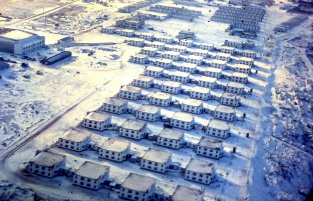
About a mile south of the base was an Eskimo village built in the mid-1950's by Indian and Northern Affairs under the "Arctic Wings" program. It was named Camp 20 and also referred to as Akudlik. The first building into the camp, which is on a diagonal, was the Eskimo co-op store where anyone could purchase soapstone carvings and other art items.
After moving into Camp 20, the Eskimos sold (traded) their supplied stoves and replaced them with 45 gallon drums. They went back to starving and to everyone's shame trudged daily, with whole families, past the Permanent Married Quarters at Fort Churchill to scavenge the town dump. They returned late in the evening with bags of edible garbage.
In 1966, Indian and Northern Affairs built another housing development
behind Camp 20 which was known as Camp 10B which replaced the Indian
housing area in Churchill (Camp 10). Initially both camps were off
limits to base personnel but as time went on a distinctive path developed
between the HMCS Churchill and Camp 20.
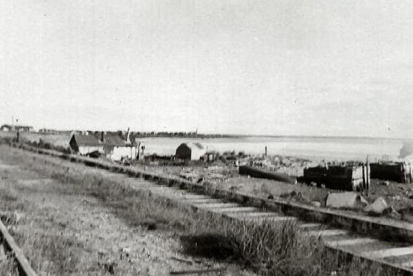 |
| 1961: Some shacks near the Harbours Board property with Camp 10 in the background. (Photo by David Smith) |
One of the personnel who was stationed at Churchill was married to an Eskimo who lived in Camp 20. One evening, this Churchill matelot came upon a fire in one of the houses and crawled through a window and rescued an elderly man and child. The fire chief declared the sailor to be a hero and he was nominated for a hero award. After a lengthy investigation by police, firemen, government officials, Royal Canadian Navy officials which went on for months, the sailor received a hero's medal. HMCS Churchill held a ceremonial parade and Lt. Tug Wilson pinned the medal on the chap. That was either late 1967 or early 1968.
Doug Stewart recalls a COs memorandum, which in essence said, " the young ladies of Akudluk may be invited to station functions. The sponsor was to ensure that nothing would bring embarrassment to the Navy or the Queen." Regardless, fraternizing with the Natives was an offence under Federal law and QRCN.
George Fraser recalls one incident" I remember CO Doug Walker
asking us to identify local businessmen to
invite to the Wardroom as associate members in an effort to add to
our social lives. I invited the Manager of the
Hudson's Bay Company store from the Town of Churchill. He showed up
with his Eskimo wife. That shook some folks up as it turned out, she was
better behaved then some of our wardroom members".
 |
|
|
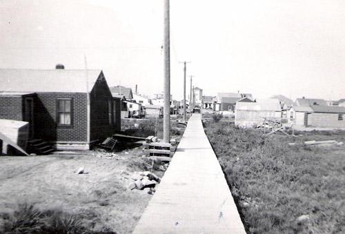 |
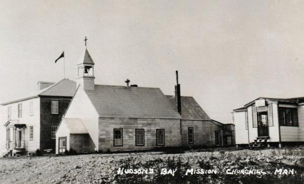
| 1956: The Boardwalk. This photo is typical of the Churchill building architecture. The area was known as the boardwalk because of the box built to cover a steam heated water line. It is believed that the line was placed to supply the RC Mission which is seen at the far end. Any of the residences along the boardwalk were allowed to tap into this line. Water taps were placed at points on the line thereby allowing other townspeople to gather water for their own use. (Photo by Doug Stewart). |
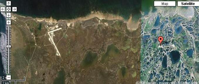 |
| The red marker denotes the former Churchill rocket launch pad which became largely inactive by 1990 with the last firing of a Black Brant on April 28, 1998. This site is now home to the Churchill Northern Studies Centre located at 23 Launch Road at coordinates 58°44'3" N, 93°49'13" W. The Centre is a non-profit sub arctic field station dedicated to research and education by scientists studying birds, bears, archeology, plants, and much more. Does anyone know the boundaries for the entire rocket range? (Image courtesy Google Maps) |
The Encyclopedia Astronautica web page provides some excellent history about the Churchill Sub-orbital Launch site.
"Fort Churchill is an Arctic site on Hudson Bay with a rail link and is near the point of maximum auroral activity. This combination of circumstances made it ideal for far-north sounding rocket launches. In 1954, the Canadian Army conducted the first series of rocket firings at Fort Churchill. Following a period of inactivity, construction of more elaborate facilities in support of the International Geophysical Year (IGY) began in 1956. IGY firings began in July 1957. The range was closed again in December 1958 after the IGY program ended. It was reopened again in August 1959 by the US Army as part of its network of sounding rocket stations. This allowed use of the site by other groups over the years.
In late 1960 a fire largely destroyed the facilities at Fort Churchill. It was announced that twelve Canadian Black Brant rockets would be launched from NASA's Wallops Station, Virginia in 1961-1962 while the facilities were rebuilt. When the United States decided to end its activities at Churchill by June 1970, the Canadian National Research Council took over operations to support the Canadian Upper Atmosphere Research Program. The Canadian military also found the site useful for characterization of the ionosphere for military communications.
By the 1990's the facility was inactive and an attempt was made to privatize it. At an announced cost of $ 300 million, it was said that Akjuit Aerospace would develop 'SpacePort Canada' at the range. This was envisioned as the worlds first international, commercial polar space port, with three launch complexes capable of launching sounding rockets, small orbital launch vehicles, and medium orbital launch vehicles. A Mission Control Centre would control launch operations. A deal was signed in 1996 for Russian Start booster orbital launches to begin in 1998. However the collapse of the space launch market brought an end to those ambitious plans".
This site is now home to the Churchill Northern Studies Centre (CNSC).
Michael Goodyear, Executive Director (2006) said " the CNSC purchased the
operations building, the meteorological station, and the generator shed
from the National Research Council in 1985 for one dollar. We do
not have any purpose built structures, although we are in the midst of
initiating a capital fundraising plan to raise the $10 million required
to create a new purpose-built research and education facility on site,
perhaps incorporating portions of the Operations Building as a museum/attraction".
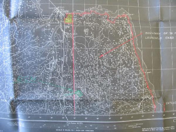 |
| The red markings on this relief map are believed to be the boundaries of the Churchill rocket range. Can anyone confirm? The green rectangle to the right of the vertical red line is the abandoned base at Chesnaye. In yellow is the general area in the vicinity of HMCS Churchill and Fort Churchill. There is no southern boundary shown on this map so the range might have extended further south than shown. (Map courtesy National Archives. Submitted by Joe Costello) |
 |
| Those who served at HMCS Churchill will be familiar with Wat'chee Lodge. Adjacent to the new Wapusk National Park (est 1996), it was used by fishermen and hunters. In the Cree language, Wat'chee means "a hill covered with trees in the middle of the tundra". The lodge is located 40 miles south of Churchill at Lat: 58.73N, Long: 94.05W and located on the same property as the abandoned Chesnaye Transmitting Station. (Graphic courtesy Wat'chee Lodge) |