Frobisher Bay
INTRO
 Naval Radio Station (NRS) Frobisher Bay call sign CFI, was established
in July 1954 on Baffin Island as a result of the closure of NRS Chimo,
Quebec. In June 1957, it was renamed HMC NRS Frobisher Bay until July 1966
when it became CFS Frobisher Bay. To those who served there, it was always
referred to as NRS Frobisher Bay. This part of the North West Territories
became the Nunavut Territory in 1999.
Naval Radio Station (NRS) Frobisher Bay call sign CFI, was established
in July 1954 on Baffin Island as a result of the closure of NRS Chimo,
Quebec. In June 1957, it was renamed HMC NRS Frobisher Bay until July 1966
when it became CFS Frobisher Bay. To those who served there, it was always
referred to as NRS Frobisher Bay. This part of the North West Territories
became the Nunavut Territory in 1999.
Frobisher was a tender to GLOUCESTER, as was Gander, Aklavik,
Masset, Bermuda and in its day, Chimo. None of them had an official badge,
at least as tenders. Gloucester provided all the administrative functions,
pay etc, in its capacity as home to the Senior Officer, Supplementary Radio
System (SOSRS). In actual fact, SOSRS was also the Commanding Officer
of HMC NRS Gloucester which became HMCS Gloucester sometime around
1956.
NRS Frobisher was part of the SUPRAD (Supplementary Radio) network.
In its simplest form, a SUPRAD station operated in the following manner.
When a prospective target made an emission which was heard by the Control
Center, Control "flashed" the details of the emission (frequency and call
sign) to the SUPRAD stations of the network. The stations tuned the signal,
took bearings then reported the bearing to Control. At Control, the bearings
were collated by computer and a fix area established.
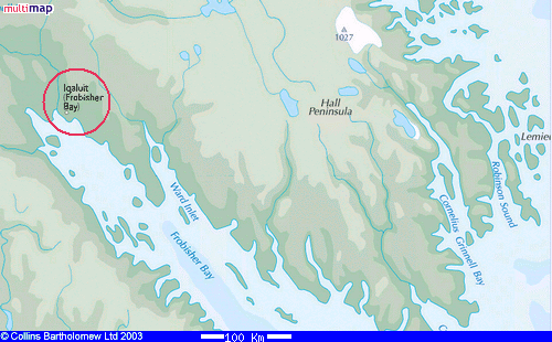 |
| Frobisher Bay, 63° 45' N 68° 33' W, can be found
in the southern portion of Baffin Island in Northern Canada. Today it is
known as Iqaluit and is now the capital of the territory of Nunavut.
(Map
courtesy of Multimap.com) |
HISTORY
During WWII, the U.S. Government built a military airstrip at Frobisher
Bay which was then purchased by Canada in 1944 for $6,800,000. When the
radio station was established it was built by the air base.
In 1950, the RCN and the USN formally agreed to coordinate and standardize
HF/DF activities ashore. Jointly, it was called the Atlantic HF/DF
Network. This initiative resulted in the integration of all Canadian and
US stations into two networks which would provide mutual support for the
common objective of maritime warfare. The eastern network was comprised
of five RCN stations: Coverdale, NB; Gander, NFLD; Frobisher Bay
N.W.T (when it came on-line and Chimo before that) ; Bermuda (1963-1993
only), Gloucester, Ont. and ten USN stations.
By 1952, the RCAF had 20 to 24 men stationed at Frobisher which included
the Commanding Officer and sufficient staff to operate the flying control
facility. The USAF staff numbered around 150 and continued to be the major
user of the base.
Ray White provides some details about the start of operations for NRS
Frobisher Bay. "The move of the various pieces of gear from Chimo to Frobisher
Bay took place in late summer 1953. In May or June 1954, the RCN had one
Petty Officer in Frobisher, namely, P2CS3 Bill Cummings. On the 29th of
July 1954, the inaugural crew arrived in Frobisher. At that point we commenced
the construction of the ground mat for the Adcock array, moved the
DF shack into position and then we built the emergency power building.
HFDF net operations did not commence until late September 1954".
A government cabinet document from 1956 indicates that Frobisher was
under the jurisdiction of the RCAF, but it was the USAF which provided
the necessary personnel and the airfield equipment. The Department of Transport
provided radio and meteorological personnel and planned to erect a new
building during that summer. Frobisher Bay and other northern outposts
were prime examples where U.S. and Canada shared common infrastructure
for their mutual benefit.
NRS Gander and Frobisher had a mandate1 to provide support
to Coverdale and other SUPRAD2 stations in the area of SIGINT
and D/F operations, and a government research program which studied the
problems of radio transmission and reception peculiar to Canada. This involved
the use of classified equipment. Whether this actually happened remains
unconfirmed.
 |
|
The D/F shack as it appeared in the 1950's. (Photo by Cal Diamond)
|
On 27 April 1955, a Douglas C-124C Globemaster, operated by the USAF,
landed short of the runway and broke up. Although there were no fatalities,
the aircraft was written off completely. Ray White, who served at NRS Frobisher
Bay, was on duty when it happened. "I was coming off watch from the
HF/DF shack at the north end of the runway and was walking along the runway
toward the base where the combined RCAF/RCN barracks were located. Halfway
along the runway I could see a large aircraft in the distance, over the
water off Frobisher Bay. It was banking to starboard and then straightened
out, Now I could see the landing lights. As it approached the runway threshold,
the aircraft dipped below the level of the runway, then it struggled to
climb to the correct altitude. It almost made it, but the landing gear
caught on the very end of the runway and the plane did a cartwheel which
tore off the starboard wing. The aircraft then flipped over, broke up into
many pieces and caught fire. Since I was nearly a mile distant from the
wreckage, there was not much I could do. By the time I got there, emergency
vehicles were already in action. A few spectators who also came out
to investigate were not permitted to come close to the aircraft. The outboard
port engine continued to operate for a day or so before the decision was
made to shut off the fuel supply".
 |
| April 27: It is a very rare event to see an engine still operating
after an aircraft has been totally destroyed. The USAF had a sign
near the main hangar that said "Welcome to USAF Northeast Air Command Frobisher
Bay. A naked girl behind every tree". The trouble was, there were no trees!
In the summer of 1955, the Americans used a construction battalion to extend
the northern end of the runway with a series of explosions in order to
remove part of a mountain. (Photo by Ray White) |
BASE DESCRIPTION
Ray White provides a few details about the base from the mid 1950's.
"The HF/DF shack was located at the north end of the runway, about 1.5
miles from the main base. It was just past the USAF Ground Controlled
Approach radar, from which we took our electric power. One day one
of the snow removal personnel cut the power line with the blade of his
plow and we had to operate our old Waukesha Diesel for several months before
it was fixed. It was very noisy and didn't provide quite enough power
to operate the two Hammarlund SP-600 receivers, the CNF-4 HF/DF set, the
lighting and most importantly, the hotplate for coffee and for cooking
snacks. To work around the problem, we would power off all the operational
gear during the cooking period!. The operator on the reporting circuit
in the Ops room in the main base would respond to NSS (network control)
with OS (Out of Service status) for the various flashes we had missed.
NRS Frobisher Bay used CFI for Atlantic HF/DF net reports to NSS Cheltenham,
Maryland and for administrative communications with CFL Churchill, Manitoba;
VFU8 Padloping Island, NWT; and also CGVM (HMCS Labrador).
We had no administrative, medical, or cooking staff.
Instead we used the facilities of the USAF. The RCAF Commanding Officer
was Squadron Leader James Lovelace, DFC, who had flown with Bomber Command
during WWII. S/L Lovelace was the senior officer in Frobisher. This
was mainly a political decision to ensure that a base on Canadian territory
would not be commanded by a USAF Officer. The USAF AC&W squadron
was commanded by Major Robbins. In late 1954, Major Robbins was replaced
by Lieutenant Colonel Jerry D. Miller, and thus S/L Lovelace was replaced
by another RCAF officer one level higher in rank, Wing Commander Campbell-Rogers".
In 1958, on request from the US Navy, NRS Frobisher began as a Naval
Communication Facility (NAVCOMFAC) providing a relay point for communications
with United States Military Sea Transport Ships (MSTS) engaged in replenishment
and supply of Distant Early Warning (DEW) surveillance stations in the
eastern Arctic.
On 26 August 1961, 150 seamen from the Canadian frigate Cap de la Madeleine
landed at Frobisher Bay to assist with the construction of new crew barracks.
This came as a result when normal methods of construction could not provide
badly needed living quarters due to the short summer navigation season.
Accompanied by the supply ship Eastore and aided by Department of Transport
landing barges, the Army-style buildings and personnel were successfully
transferred to land. More than 150 tons of cargo were moved a mile inland
in spite of freezing temperatures and snow flurries. Building the barracks
was easy getting the material to shore was the hardest part. Two
hours after the last cargo was landed, a gale forced Cap de la Madeleine
to withdraw from the reef-strewn bay into deeper waters off shore.
It took the frigates crew two days to erect the 110 foot long building
and on the third day they wired it, applied the roof and painted the interior
a pastel green. After remaining 11 days at Baffin Island, Cap de la Madeleine
sailed for Halifax leaving behind eight men to finish insulating the building
against Arctic weather. These men were to be flown out later.

|
|
Chateau Madeleine The House That Jack Built . (Photo courtesy
Crowsnest Magazine)
|
 |
| The crew barracks, with some modifications, is
still standing in 2023. (Photo by Christopher Reed) |
And what was the name of the new building one might ask? The frigates
crew left a sign bearing the name Chateau Madeleine The House That
Jack Built. To the occupants of the new building, it was simply called
The
Frobisher-Hilton.
George Fraser served in Frobisher Bay when the new barracks was erected.
He reports the following. "Before eight months had even elapsed in
our enjoyment of these new digs, trouble developed. One day, in early spring
1962, I was returning from the Operations Building back to camp with
the Day Watch and our one or two Administration types. A howling westerly
gale with rain and snow was pelting down upon us. When we rounded the corner,
we could not believe our eyes.
CPO Archie Reed, P1 George Finnie and the rest of our watch keepers
were manhandling very large tarps in an attempt to cover the roof of our
beautiful building whose top had just folded over. Our party immediately
chipped in to help but it was very difficult in trying to hold down those
tarps long enough to secure them.
As I remember some of the guys working on this would have been Whitlaw,
Hartnett, Tishart, Blair, Gignac, Bitz, Stanley The Posh, John Ward, Dennis
Harder and maybe some others I may have missed. In any event, all
of this rain and hail and snow drove in under the roof and started to leak
down into the messes and sleeping quarters. We had every pot, pail, and
bucket that we could get our hands on to catch the leaks. It took
a number of days before the Department of Transport was able to get
everything back to normal.
From what we could see, whoever approved the building's design made
an error since the roof's overhang was perhaps 18 to 24 inches beyond the
side of the building. No one realized that any of the gales which beset
Frobisher Bay could easily catch the the building which also sat on a small
rise of land".
Select this link
to read to read about Project Boresight and the Cuban Missile crisis of
1962.
(Click to enlarge)
 |
1948: The runway at Frobisher Bay is situated
on a bearing of 350/170 and this is how it looked before the extension
was added. At the left side is the Sylvia Grinnell River, which flows into
Frobisher Bay. When NRS Frobisher Bay started operations in September 1954,
the Adcock array for the CNF-4 D/F set was situated in the vicinity of
the red dot. North is at the top of the photo. The long, straight 'runway-like'
area at the south end of the main runway was referred to in the early 1950's
as the "West 40". It was basically a storage area for equipment, vehicles,
fuel drums, etc. The green dot indicates roughly the area which eventually
became the RCAF/USAF lower base. The radio station's barracks and Operations
Office would eventually be set up here. A yellow arrow indicates the direction
of the transmitter site. (National Air Photo Library #A11535-43) |
|
|
 |
1962: The red circle identifies the location
of the transmitter site. (RCAF photo # 204 V KR2367 405 Dated
10 Sept 1962. Altitude: 4600 ft) |
 |
1992: The landscape has changed dramatically
after several decades. North is very roughly on left side of the photo.
Item 1: The Operations Building was located here in the 1965-66
era.
Item 2: GRD-501 shack was approximately 150 yards to the right
of the little rectangular square. Item 3: Old USAF billet
where Frobisher personnel lived. At the time, it contained staff
quarters, DOT quarters, teachers quarters, the CBC studios, a large gym,
a large cafeteria, food stores and large garage for RCN and DOT trucks.
Item 4: DF shack for CNF-4 D/F when it was in use.
Item 5: Adcock array site for CNF-4 D/F set.
(National Air Photo Library #A31614-14) |
 |
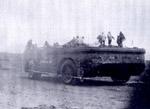
This Chrysler Military Radio Truck, built in
the 1950's in Windsor Ontario, saw service at Frobisher Bay. Photo
is Circa 1960 - 1961. (Photo by Cal Diamond) |
 |
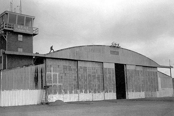
The control tower and hanger at Frobisher Bay
in 1952. (Photo by Don Gordon) |
 |
Sleeping quarters, circa 1960 - 1961. (Photo
by Cal Diamond) |
 |
Sleeping quarters, circa 1960 - 1961. (Photo
by Cal Diamond) |
 |
The Sea Lift in 1956: Ships supplying
Frobisher could not be berthed at a pier. To offload their cargoes, they
relied upon this large, self-propelled amphibious barge called a Sea Lift.
Supplying northern bases created employment for the local population even
if it was for a short time. Here the barge is manned by local natives employed
as stevedores. No enlargement for this one. (Photo by Don Cameron) |
 |
Don Cameron, Frobisher's Chief I/C between
May and November 1956 stands next to the barge. Even though Don is 6 feet
tall, the massive tire is even larger. (Photo via Don Cameron) |
 |
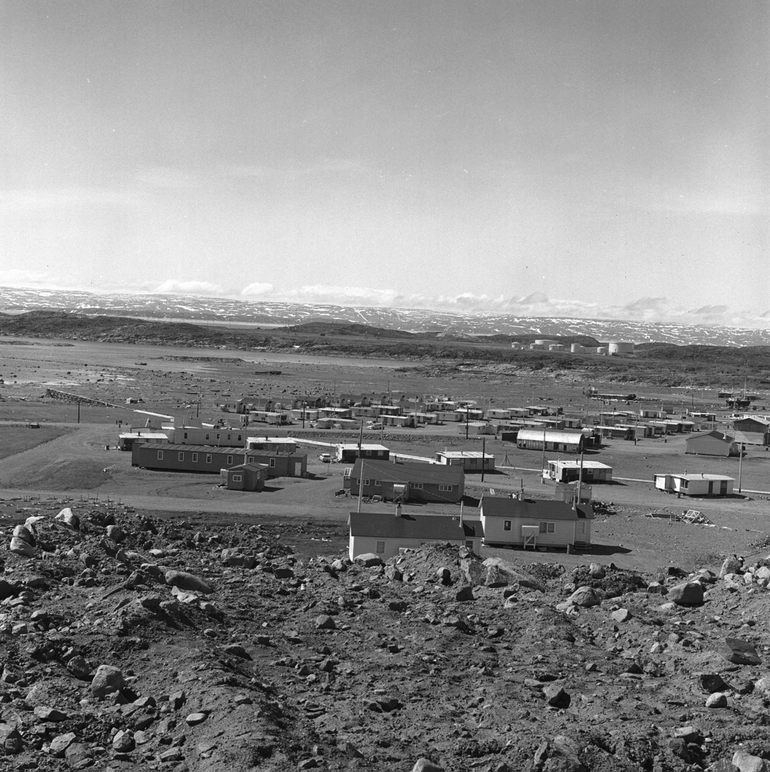
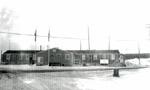
Personnel Quarters (1956): Consisted of
a tar papered building with a heating unit, heads and a lounge in the centre.
In the two wings were accommodations where each man had a single
room, bed and locker. The walls were only six feet high in order to assist
with the circulation of warm air throughout the building. (Photo by
Don Cameron) |
 |
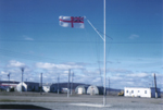
HQ (taken in 1956): This building
was the local headquarters for the USAF, RCAF, RCN and DOT. The Canadian
Ensign and the American Stars and Stripes were flown in front of the building.
RCN personnel requested permission to fly the White Ensign in front of
their section but the request was flatly refused by both the RCAF Wing
Commander and the USAF Colonel. [3] (Photo by Don Cameron) |
 |
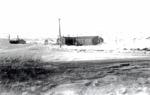
The Hudson's Bay Company Store: It was
located about three miles east of the Frobisher Bay site, on the north
side of the bay. Inside, the store stocked a wide variety of articles and
it also had to keep the locals supplied for a whole year at a time. (Photo
by Don Cameron) |
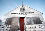 |
This is the deteriorated remains of the former
Hudson's Bay store as seen in January 2020. (Photo by David Proc)
Frobisher Bay has now been renamed to Iqaluit and is now in the Territory
of Nunavut as of 1999. There are no brand name stores in town such as such
as Canadian Tire. Perhaps one day. Locals get their supplies from a North
Mart outlet. |
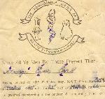 |
Honourable Order of OOKPIKS-TOONIKS-SIKUSI certificate.(Image
courtesy of Eric Earl). |
RADIO OPERATIONS
Ray White describes the layout of the operating position in 1954. "The
HF/DF shack was fitted with a CNF-4 HF/DF set and two Hammarlund SP-600
receivers. Above one of the SP600's was the centerfold pinup of Marilyn
Monroe from the first edition of Playboy in 1953. The Operations Room,
located in the centre of the base, had two bays, each equipped with two
SP600s, one of which was used for the reporting circuit to NSS/Cheltenham,
Maryland and the other for administration purposes for communication
with CFL/Churchill and, occasionally with VFU8/Padloping Island. We had
two dipole receiving antennas - one for the HF/DF net and the other for
Churchill. Frobisher had its skeds with Churchill at 1500Z and 2100Z and
the main operating frequency was 9216 kHz using CW.
The transmitter site was about two miles away. At first we had,
I believe, a Canadian Marconi PV-500HM, but there was a fire so RCAF
Commanding Officer, S/L Lovelace, provided the loan of an RCA AT-3 transmitter.
We had no spare transmitters throughout my stay in Frobisher and
we used our one and only transmitter for both HF/DF net reporting and administrative
traffic. When the time came for a schedule with CFL, we would temporarily
discontinue work with NSS to send and receive administrative traffic. Upon
completion, we would go back to HF/DF net reporting. There were two men
on a watch at all times. One was in the DF shack while the other was on
the reporting/administration circuits in the small Operations Room.
It was a very basic operation indeed. The NRB-J, CSR-5 and HRO receivers
used at Chimo never found their way to Frobisher Bay. In the lounge, we
used an RCA AR-88 for shortwave entertainment reception.
Aurora Borealis, commonly called the Northern Lights, disrupted radio
reception The effect was heard as a general reduction in the signal
to noise ratio across the HF bands. It could be heard as a continuous "whooshing"
noise in a receiver. When the lights were intense, blackouts often occurred
in the HF/MF and LF bands. Surprisingly, we often found that VLF appeared
to improve during such HF/MF/LF blackouts in the western Arctic. In Frobisher,
the image on the CNF-4 screen became a random circle of non-directional
garbage. The DOT aeroradio station was also knocked out of action.
Being south of the Arctic Circle also meant that Frobisher did not experience
any days of complete blackness or complete daylight. In June and July we
would have sunset around 2230 hours and sunrise about 0130 hours.
Chimo, considerably south of Frobisher and on the same approximately
latitude as Churchill - about 58°N, experienced much less of a "midnight
sun" effect. Aklavik, inside the circle, and Alert, very close to the pole,
had more comprehensive midnight sun effect".
Eric Earl reports that "There were also a couple of SP600's in the southern
end of the building where the USCG liaison fellow worked the cutter Northwind
during the summer ice patrol. He also had his FAX equipment in that
room where he sent updated weather and ice maps to the cutter".
In 1964, an entry in the Naval General Orders (NGO's) authorized Frobisher
Bay to hold 40 telegraphic typewriters.
Click on image to enlarge.
RADIO EQUIPMENT USED
Any additional details are provided below the table.
(Click on image to enlarge)
 |
AT-3: In the RCAF, the AT-3 was designated
as 10D/1272. It could be operated locally or remotely using the 10D/1273
remote control unit. A pair of remote control units can be seen sitting
on top of the transmitter in the enlarged photo. Select this
link for more information. (Photo courtesy SPARC Radio Museum,
Coquitlam, BC.) |
 |
AT-3: An unidentified operator is using
the AT-3 transmitter which has been paired up with a Hammarlund SP600 receiver.
Click on image to entage. (Photo taken by Art Deer who passed
away April 2012.) |
 |
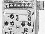
Sparton CNF-4: A CRT based set having
2.7 mc to 25 mc coverage depending if it was the A, B or C variant. In
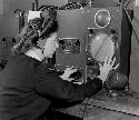
1954,. Frobisher had two positions and two operators some of the time.
(There were no WRENs at NRS Frobisher Bay as the picture might imply).
In the RCAF, this set was known as the DF-23. The CNF-4 was later superceeded
by the AN/GRD-501.(Photo by Leblanc, DND. National Archives of Canada,
photo # PA-142540) |
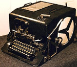 |
ECM MK 2. Used for the encipherment of
classified material. (Photo by Richard Myrick) |
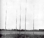 |
The Adcock array used with the CNF-4 set.
It was located approximately 800 feet to the south and east of the
DF shack. (Photo courtesy Report No ERA-141 "The War History of the
Radio Branch" issued by the National Research Council of Canada in August
1948). |
 |
AN/GRD-501. Eric Earl, KG4OZO, now
living in Atlanta, Georgia was a former CS rate and he confirms the use
of the AN/GRD501 HFDF set while he served at Frobisher from 1965 to 1966.(RCN
photo) |
 |
Hammarlund SP-600 Receiver : Coverage:
0.54 mHz to 54 mHz, in six bands. SP-600's were produced between
1950 and 1972. (Image courtesy Kurrarjong Radio Museum) |
 |
Canadian Marconi PV-500HM Transmitter:
Range - 3 to 19 mHz. 500 watts. Crystal or VFO control. CW or MCW only.
After it was damaged by fire, the PV-500 was replaced by the AT-3. (Image
courtesy RCN) |
| Need photo |
TH 58 transmitter. 1 kw output. Used for point-to-point communications
with Churchill. |
 |
Westinghouse MW. 3 kw output. Able to transmit
on 4 frequencies simultaneously or independently. Proposed for Frobisher
Bay but its unconfirmed at this time if it was actually installed. It was
to replace the TH-58. Depicted here is a triple MW installation at
radio station WNU Slidell, Louisiana. Frequency range: 2 to 30 Mhz;
Modes: A1 and F1; Frequency control: 3 crystal controlled positions per
RF unit. All four RF units can be keyed simultaneously or independently.
Instruction Manual: CF-1933 (Photo courtesy WNU6) |
RCA Model AT-3 Transmitter Specifications
Type: Semi-mobile ground station transmitter
Frequency control: 2 channel, crystal controlled plus Master Oscillator.
Frequency range: 2.5 to 20 mHz
Modes: CW/MCW/RT
Power input to final stage : 450 watts (1500 volts @300 ma)
Power output : 300 watts
Power consumption - 115 VAC @60 Hz 1.75 kw
Dimensions: Height - 68 inches; Width - 32 inches; Depth - 22 inches.
Weight: 630 pounds (286 kg)
The AT-3 was equipped with a four-hole telephone dial and the operator
could select both the mode and frequency by dialing a single digit. Dialing
#1 for Channel A, R/T ; #2 Channel for A, CW; #3 for Channel B, R/T; #4
for Channel B, CW. When in operation, an internal motor tuned all the controls
in the intermediate power amplifier ( IPA) and final stages to preset positions.
Eric Earl, a former CS rate, remembers some details about the antennas.
"The antenna that I worked on was out at the DOT transmitter site which
was located approximately 3 to 5 miles to the south of the Operations Building.
This site contained all the antennas used by DOT(VHF)/ DOT(HF) Arctic Air
Traffic control and of course our wire antenna(s) . There was also one,
large, fixed wire log-periodic antenna out there which was used by the
telephone company as a fixed link to Northern Quebec. Periodically, we
did have a USN naval type who used our transmitter to send ice charts to
the cutters Northwind and Westwind from the Ops Building.
Ray White recalls the use of the ECM
crypto machine. " We used the ECM as our administrative crypto channel
and we would certainly curse the originators of long-winded messages that
had to be a) copied in CW and b) broken by the duty operator. I can
still remember being told as I came on watch that we had a lump-jump
to break. Lump-jump was our way of indicating the arrival of an ECM
message bearing the first group LYJPM that told us that it was the Canadian
channel emanating from DSRA and naval headquarters. Surprisingly, the ECM
was mainly problem free for us except for coping with the loquacious tendencies
of the originators".
AMATEUR RADIO
Amateur radio at SUPRAD stations was not encouraged by DND. It wasn't
forbidden, but definitely played down. Station Standing Orders had explicit
instructions that contacts with the USSR or other Iron Curtain countries
was explicitly forbidden. Other countries were also listed where communication
was prohibited. This made amateur radio operations very tenuous in the
Arctic.
Ray White operated a station here. "At Frobisher Bay, in the 1954/55
period, I operated as VE8WD out of the common DOT/USAF amateur radio
station that was equipped with a BC610 transmitter and a couple of wartime
Bendix receivers. When American military personnel used the station , they
used a stateside call sign with a VE8 suffix. We worked some CW but most
of the time AM voice (A3) was used. Most of the operating was done in the
20 and 40 meter bands.Our tag line was VE8YT in the banana belt of the
Canadian Arctic.
The limitation of no contacts with Iron Curtain stations was just as
frustrating as when I was posted in Churchill. Other Canadian operators
were Sonny Gough, head of the DOT aeroradio station and Nels Peart, one
of the DOT operators. They used call sign VE8YT which I dearly coveted
because the YT sounded like my last name when said out loud and quickly.
Sonny set up VE8YT which was both the DOT and the RCN callsign.
I can still hear Brit Fader VE1FQ, a famous amateur operator now honored
in Halifax responding to our calls. Typically we would say " this is VE8YT
in the banana belt of the Arctic". Brit made many phone patches for us.
Also, we had many good conversations (QSO's) because VE8s were somewhat
rare. A regular correspondent was VK0PK, operated by Peter King, on MacQuarrie
Sound in the Antarctic! I don't know if ham radio operations continued
in Frobisher after I left in 1955".
In that era, it was DOT practice to accept the RCN electronics training
as proof of ability to qualify for an amateur radio licence. All that was
required was to have a letter from the Chief in charge (and later on) from
the Officer In Command, that the individual had met the RCNs trade requirements.
By 1963 the following individual VE8 amateur radio call signs were assigned
to the naval radio station.
VE8YB Thomas E. Eastop
VE8YC Maynard B. Whitlaw
VE8YE. W. Crumley
VE8YK George Fraser
VE8YL Alexander B. Peddle
VE8YN Bruce E. McGuffle
VE8YO John R. Bullas |
VE8YQ Robert W. White
VE8YR Jean-E. Rioux
VE8YS Dennis D. Harder
VE8YU Lewis H. Jessome
VE8YV M. G. J. LeMay |
A story about amateur radio communications in the RCN can be found
here.
PERSONNEL
Ray White recalls the inaugural complement of personnel in 1954. They
were:
C2CS3 W. J. (Wiggy) Bennett, CPO in charge
P2CS3 Edward G. Amy, Operations Supervisor
P2CS3 George T. Finnie, Technician (replaced in 1955 by P2CS3
K. Gallagher)
LSCS2 (uncertain about rank) Gerald Bursey
LSCS2 Douglas L. Cox
LSCS2 James R. Christmas
LSCS2 N. G. Dodd
LSCS2 Patrick C. Kilen
LSCS2 R.P. White
ABCS2 C.E. Atkins
ABCS2 Richard Turcotte
ABCS2 J. T. Beardsley
Also present during the initial set-up period was P2CS3 W. G. Cummings
who had been in Frobisher since the arrival of Chimos equipment.
The following people sserved at Frobisher Bay in 1961:
Maurice (Moe) Potvin ABRN1
Unknown Perry ABRM1
CLOSURE
NRS Frobisher Bay was a useful HF/DF station by reason of its location,
particularly with respect to ocean areas of prime interest to Canada but
it was also expensive to operate for its size because of its remoteness.
By the mid 1960's, advancing technology underscored the need to reevaluate
SIGINT and HF/DF operations since there was some opportunity to save on
operating costs. By closing the station, the government could save $222,000
per year.
By August 1963, the effectiveness of NRS Bermuda operations was such
that it soon became obvious that Bermuda was to stay. It had passed its
probationary period with flying colours. But the opposite was experienced
at Frobisher Bay. That station subsequently closed down as a direct result
Bermuda's proficiency. Bermuda had delivered its mission - "to effectively
provide cut-off bearing for accurate fixes on transmitting targets.
As a result of reorganizing and modernization under Project
Beagle, NRS Frobisher Bay closed in 1966. The "Upper site" of the station
was abandoned in 1974. while the "Lower site", renamed Iqaluit, has been
a Forward Operating Location since the early 1990's. The airfield is still
in use today.
The mailing address used to be:
Naval Radio Station Frobisher Bay NWT
Via RCAF Station Goose Bay, Labrador.
 Naval Radio Station (NRS) Frobisher Bay call sign CFI, was established
in July 1954 on Baffin Island as a result of the closure of NRS Chimo,
Quebec. In June 1957, it was renamed HMC NRS Frobisher Bay until July 1966
when it became CFS Frobisher Bay. To those who served there, it was always
referred to as NRS Frobisher Bay. This part of the North West Territories
became the Nunavut Territory in 1999.
Naval Radio Station (NRS) Frobisher Bay call sign CFI, was established
in July 1954 on Baffin Island as a result of the closure of NRS Chimo,
Quebec. In June 1957, it was renamed HMC NRS Frobisher Bay until July 1966
when it became CFS Frobisher Bay. To those who served there, it was always
referred to as NRS Frobisher Bay. This part of the North West Territories
became the Nunavut Territory in 1999.