MOUNT DOUGLAS , BC. VHF/DF
As a result of being asked to identify a concrete structure
at Mount Douglas Park in British Columbia, the ensuing research effort
unearthed a WWII era Fighter Control Network. It was previously thought
that the remains at Mount Douglas Park were that of a secret WWII High
Frequency Direction Finding station based on old newspaper and city
archives that used the term Huff-Duff as well as long term residents terming
it "secret". This idea for the site purpose was furthered with the discovery
that the Beeston Hill site in the UK looked similar and had similar dimensions.
More recent information makes it clear that new information changes the
picture.
Starting in 1942 , the RCAF installed and operated a VHF Direction
Finding service atop Mount Douglas, a short distance from wartime Victoria
B.C. It was part of a FIghter Control Network whose mission would be to
direct fighter aircraft in case of attack by the Japanese. In the 1940s,
VHF was considered to be 99 to 156 MHz as noted in the VHF Fighter Control
manual, and not 30 to 300 MHz as it is today. Installations which had the
capability to perform VHF radio direction finding (VHF/DF) were called
"fixers" . (When the direction finding station determined the bearing
of a signal, it was termed a fix.) The bearings measured by the fixers
would sent to a central control point which had the authority to
dispatch fighter aircraft. So far the remains of two fixer stations
have been identified. These are: Mount Douglas and Point No Point,
all in British Columbia.. A much smaller hexagon base was found on Radar
Hill near Tofino.
A key element of this defensive system was the centralized Filter Room;
the point at which all information was gathered, consolidated and assessed
in order to determine how to respond to the threat. Reports of aircraft
operating offshore were phoned in from friendly ships, Coast Watchers,
radar stations and Air Force Bases. The Filter officer would use experience
to decide when a plot would be displayed, and how to label it; friendly
or enemy, number, altitude, heading, etc. There were two such Filter Rooms
on the West Coast; -one in Vancouver and another in Victoria.
The room for the Victoria area was known as "No. 2 Filter
Room" for Western Air Command. So where was the Victoria Filter Room
located.? The answer can be found in the story titled "Victoria's
Secret" by Doug Rollins, the Librarian/Historian at the BC Aviation
Museum
 |
Canadian West coast patrol areas and radar coverage
in 1944. Click on thumbnail to enlarge. (Provided by Doug Rollins, BC
Aviation Museum)
The story titled " Radar
Detachments on the West Coast of Canada" by Chris Weicht, details the
problems that were encountered in establishing radar coverage and patrol
areas for Western BC. |
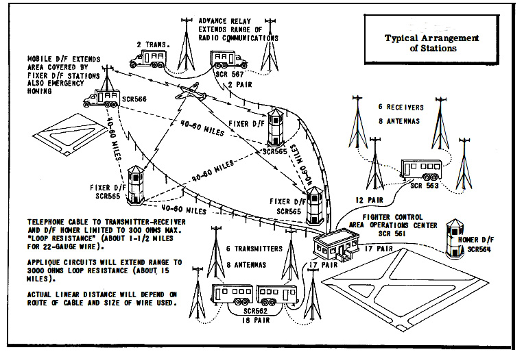 |
| This is a generic diagram of a VHF fighter control system, The Canadian
setup might have been similar to this. There were three
"fixer" stations and one :"Homer" station in the network. The fixer
used the SCR-565 sets with the RC-82 antenna. Fighter Control systems bore
the designators of SCS-2,
SCS-3 and the Superman System. A magnified version of this network
diagram is available here. (Via VHF Fighter Control
manual) |
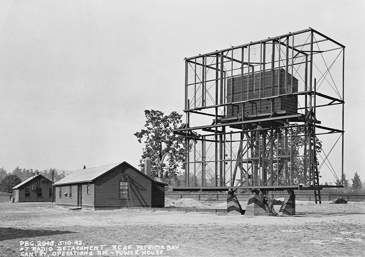 |
| Separate from the Fighter Control Network was a series of sites designed
to provide radar coverage for Western British Columbia. Shown here is the
SCR-588 Ground Control Intercept (GCI) radar installation at Patricia
Bay taken in October 1942, From left to right: Power House, Operations
Building and the SCR-588 antenna. Detected targets of interest
would be reported to the associated Filter Room as there were three of
them . Other radar sites used Chain Home Low (CHL) radar. SCR-588
was the Americanized version of the British CHL/GCI set built by the Canadian
company, Research Enterprises Limited.
Range: 105 mi in search mode, 45 mi in GCI mode.
Peak Power: 125 kw
Operating frequency: 209 MHz.
This radar set could be used as both a medium range search radar and
as a shorter range GCI radar with height finding capability. (Photo
courtesy BC Aviation Museum) |
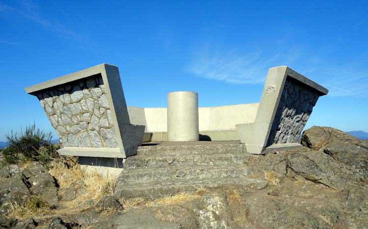
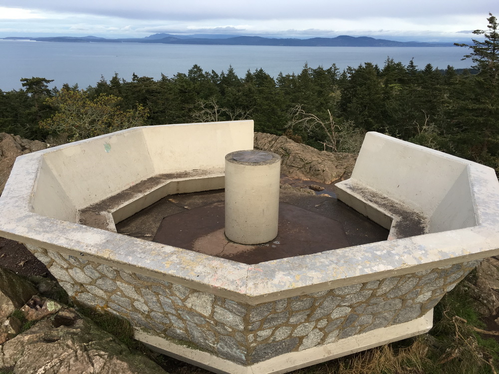
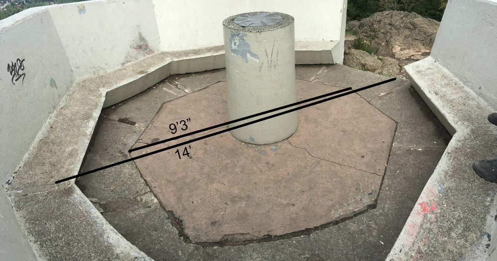
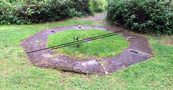
At Mount Douglas, only the octagon pedestal for the DF equipment
remains today but two eyewitnesses, namely Joan Stewart and ,Al Smith,
both verified that the installation atop Moumt Douglas appeared to
that of the one installed at Beeston Hill, England. The tower resembled
a farm silo and was about 15m high with antennas on top of it. Recently
discovered distant photos clearly show a tall silo structure at the summit.
To obtain a fix on a target, control central would have to apply two
or more DF bearings on a map, The point where the bearings converge
is called the fix
Another VHF/DF station at Point No Point, BC. was discovered with identical
octagon base dimensions and also photos showing the silo structure. There
exists a concrete hexagon pedestal on Radar Hill in Tofino BC, with currently
unknown purpose.
 |
 |
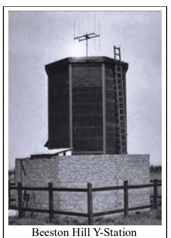
| The VHF/DF system installed at Mount Douglas was similar to the one
at Beeston Hill, UK. British VHF/DF stations monitored German
E-Boats and bombers which used the low VHF band. (40 to 50 MHz) for
communications (Photo via Wikipedia)
The equipment used for VHF direction finding was typically located atop
a hill in a small octagonal shaped hut. Operators would intercept
and obtain bearings on targets of interest. |
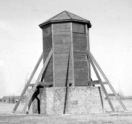
This image, taken at Southwold , Englamd
in 1944 illustrates a VHF/DF structure with a pointed roof. |
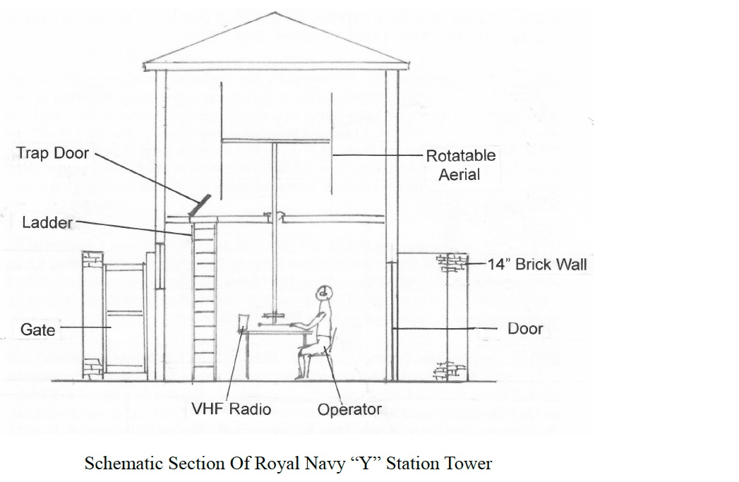 |
| This is a generic, cutaway diagram of a fixer
station.. In England , the DF system was used to obtain bearings on German
E-boats and aircraft. |
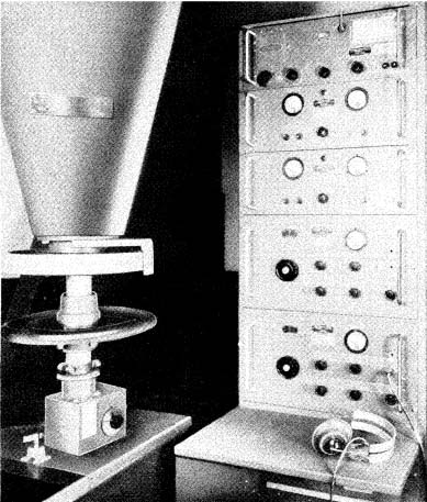 |
| This is the operators position for the SCR-565
VHF/DF system. Two major components are the BC--639 receiver and the lower
mast assembly of the RC-82 antenna. . More detail on these systems
can be found in the Fighter Control Manual listed elsewhere in this document.
(Fighter
Control Manual)
During WWII, "SC" was used to denote a complete system, with one and
two-letter suffix designators (such as "BC", for basic component, "FT"
for mounting, etc.) were used for components. Only a few system designators
were used:
SCM Set, Complete, Meteorological
SCR Set, Complete, Radio
SCS Set, Complete, System |
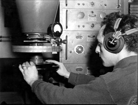 |
| In this particular installation, the 100
to 156 MHz VHF receiver is the BC-639 The Canadian fixer sites did
not have the outboard meter attached to the azimuth scale. That is
part of RC -153 antenna. (Photo C60477AC taken at
Saffron-Walden England on September 1945 provided by Clive Kidd)
) |
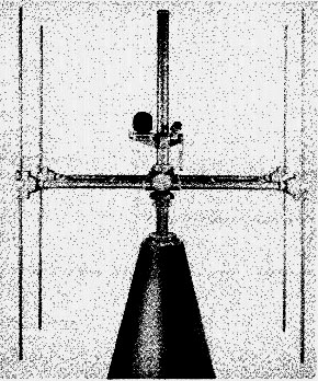 |
| Topmost portion of the RC-82 antenna is a steerable Adcock
array .The vertical rod in the middle is the sense antenna which allows
the operator to determine the true bearing. A tuned coupling unit
is provided to: match the antenna to the receiver Each RC-82 antenna
cane with the rod set: shown below. By selecting a particular
rod set, the installer could optimize which portion of the 100 to 156 MHz
band would be monitored.
Qty 8 rods, 28 in. with plug on each end. Resonant frequency = 100 MHz
Qty 8 rods, 23 in. with plug on each end. Resonant frequency = 122
MHz
Qty 8 rods 21 in. with plug on each end. Resonant frequency =
133 MHz. |
VHF/DF OPERATION
Radio set SCR-565 is radio direction finding equipment used to obtain
a bearing of an aircraft. The operator of the radio set obtains a bearing
from the radio signals emitted by the aircraft. This bearing is the direction
of flight from the individual direction finding "fixer" station. The station
operator then reports the bearing of the aircraft to the operations
block by wire telephone.
Researcher and radio collector Tom Brent provides this backgrounder
on VHF Direction Finding
STAFF ACCOMMODATIONS AT MOUNT DOUGLAS
At this time it is believed that at least 4 operators would be
needed to man the Mt. Douglas installation. That would provide for
7 x 24 hour coverage with one day off per week for each operator. . It
is believed that Mount Douglas personnel were shuttled back and forth
from HMCS Givenchy at the Esquimalt navy base.
HISTORY OF THE MOUNT DOUGLAS SITE
Darrell Wick, President Friends of Mount Douglas Park Society
(2020) provides this history about the site:
Road to summit was completed in 1939.
At the summit is a concrete octagon base. It has similar dimensions
to the Beeston Hill Station. It has what appears to be a cable tunnel leading
from the interior to the outside. There is a more recent wall and bench
structure that was built in 1960 on top of the original octagon.
The base of wood power or phone poles have been found in the vicinity.
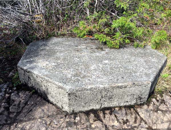
I have seen and taken photos of a similar hexagon base at Radar Hill
near Tofino.
Two people that lived in the area during WWII told me in 2015 that
there was a secret military base at the summit and they were not allowed
to go there. Their description matched photos of the Beeston Hill Station.
A BC Archives photo from 1944 show a large diameter tower structure
at the summit.
The structure was removed sometime prior to 1950.
The site is an excellent VHF site with line of sight to Strait of
Juan de Fuqua and Sails Sea. Line of sight to the Victoria airport is blocked
by Mount Newton, which overlooks the airport.
Mt Douglas is within Mt Douglas Park and within the Municipality
of Saanch. However, the park was originally a conditional crown grant to
Victoria up until 1990 when it was returned to the province. It was then
conditionally granted to Saanich in 1992. In both cases, the grant condition
related to maintaining the park as a natural park.
While Mt Douglas Park was with Victoria, but located within Saanich,
it was managed by a joint Victoria-Saanich committee. I have not found
any mention of this military site in the sketchy committee minutes. I never
found anything relevant in the Victoria archives.
A little ways away, a bit lower down, is a 1x1x1 Meter concrete block.
On the top four corners are small holes (depressions) and one in the centre.
Nothing else.
A little further down is a large pond that we think has a man made
dam.
There has been and currently is another VHF radio side 150 m to the
southeast. I do not know when it was first constructed. This has nothing
to do with the summit military site.
BACK THEN PHOTOS
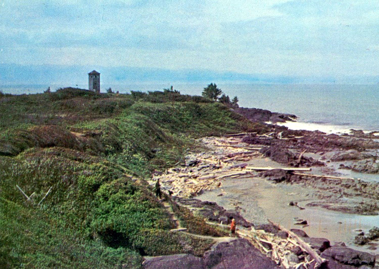 |
| POINT NO POINT, BC : As seen from this
view on the beach next to the Juan De Fuca Strait. (Photo credit unknown) |
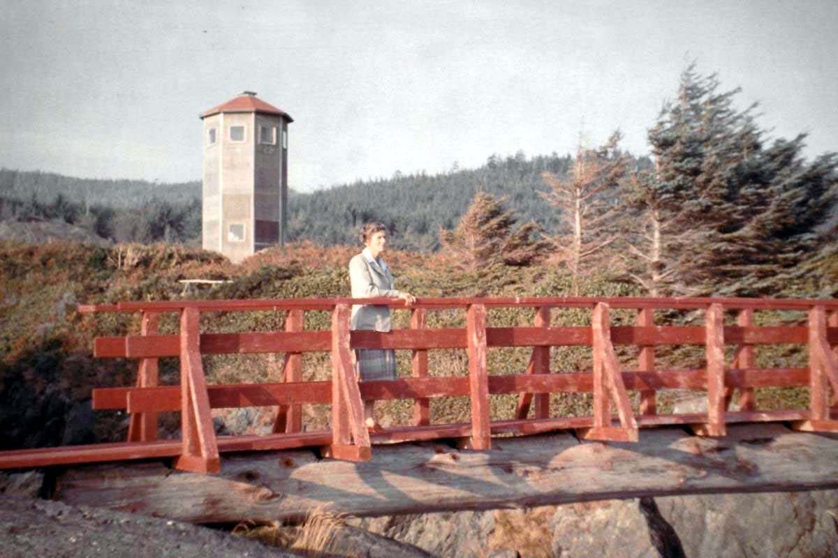 |
| POINT NO POINT, BC : This photo , taken in 1955, shows
a TR-17 VHF/DF installation. It housed the SCR-565 equipment as shown in
the network diagram . The structure collapsed in 1966. All that remains
is the base. Point No Point was formerly called. Glacier Point .
Evelyn Packham, a Registered Nurse who had served as matron at the Army
hospital at Terrace during World War II, bought the large tract of land
in 1952, at a time when the west coast rain forest was beginning to regenerate
after extensive logging had taken place there during the 1930s. Evelyn
eventually developed the property into a lodge which is still serving vacationers
today. (Photo of Rosemary Owen taken by her husband Gwyn Owen.
Sooke News Mirror) |
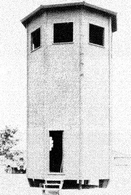 |
| This structure, whose image appears in the Fighter Control Handbook
(page38), identifies the structure in the colour photo as type TR-17.
The tower is a prefabricated three-story, octagonal building capable
of easy assembly in the field. It is designed to house radio set SCR- 564,
DF homing station, or radio set SCR- 565, DF fixer station. Tower TR- 1
7 is so constructed that if it should become necessary to move the station
to a new location, all but the concrete base may be salvaged.
All parts for tower TR- 17 are packed in thirteen export boxes . The
boxes are designed and constructed to permit unpacking the parts without
destroying the boxes. The size of each of these boxes is as follows:
Height 30 ft, 7 .625 in.
Width of Side 5 ft, 9.25 in.
Largest Diameter . 15 ft
Between Flats 12 ft
Radio sets used with TR-17 are SCR- 564, SCR- 565
and SCR- 645 |
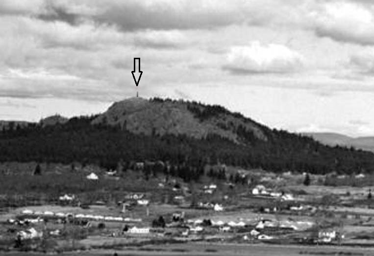 |
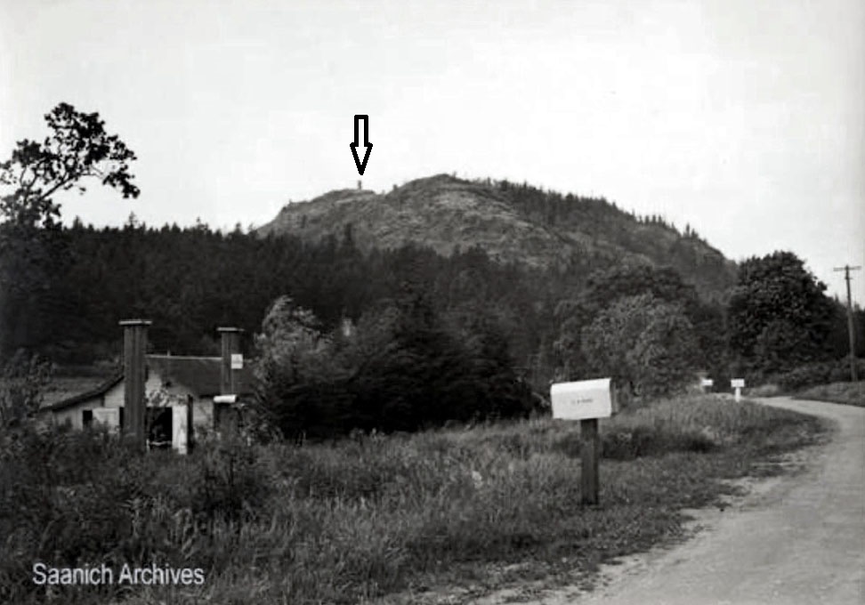
| Taken from Mt Tolmie in 1944, this photo shows
the height (225 meters) of Mount Douglas. The arrow points to the
VHF/DF installation. (From the British Columbia Archives) |
 |
| MOUNT DOUGLAS: Taken from Cedar Hill Road
sometime between 1944 and 1947.(Date based on C.A. Bird on mailbox and
records show he lived there then, but not after. (From the Saanich Archives.
Photo R-120-2012-007-007) |
WHAT'S THERE NOW?
 |
| Point No Point: All that remains
is this octagon base. (Photo by Darrell Wick) |
 |
| Tofino: , BC: Located on the western side
of Vancouver Island on Radar Hill. All that's left of the installation
is a hexagon base. .(Photo by Darrell Wick) |
Credits and References:
1) Mike.Goldsworthy <Mike.Goldsworthy(at)saanich.ca>
Park Planner + Designer; Parks Division;
Parks, Recreation and Community Services, District of
Saanich
2 Tom Brent <navyradiocom(at)gmail.com>
3) https://en.wikipedia.org/wiki/Beeston_Hill_Y_Station
4) Fall 2015 edition of the Friends of Mount Douglas
Park Society.
5) Darrell Wick VE7OB <darrellat)mountdouglaspark.ca>
President, Friends of Mount Douglas Park Society
6)
7) Clive Kidd <cjckidd(at)waitrose.com>
8) Martin Briscoe<[martin(at)mbriscoe.me.uk>
9) Stuart Rayner <stuart.rayner(at)mac.com>
10) Sooke News Mirror article from Aug 4/17
https://www.sookenewsmirror.com/community/ww11-rcaf-range-finder-found-at-point-no-point/
11) VHF Fighter Control document http://www.radiomanual.info/schemi/Surplus_Handbooks/VHF_fighter_control_equipment_handbook_1943.pdf
12) Radio (Radar) http://www.c-and-e-museum.org/Pinetreeline/misc/other/misc5b3.html
13) SCR-588 info http://fortwiki.com/SCR-588
14) Doug Rollins, Librarian/Historian- BC Aviation Museum,
Victoria airport
Back to Table of Contents
Dec 21/20