ST. ROCH - FREQUENCIES and BROADCASTS

FREQUENCIES USED

The  books titled "List of Ship Stations" and published by The International Office of the Telegraph Union were used as a reference to construct a  table of authorized frequencies that the St. Roch could use . The data was obtained from the 1930, 1933, 1940 and 1947 editions. The dates shown should only be used as a guide. These are the frequencies authorized for the St. Roch by the Department of Marine and Fisheries who handled radio administration during the period 1927 to 1936. Then the newly created Department of Transport took over.

FREQUENCY WAVELENGTH SOURCE  MODES USE
         
214 kcs 1,400 m ITU 1930/33 A1 and A2  This was a popular working frequency in the 1930s.
375 kcs 800 m ITU 1930/33 A1 and A2  A direction finding frequency.
425 kcs  705m ITU 1930/33 A1 and A2  A  medium frequency working frequency.
500 kcs 600 m ITU 1930/33 A1 and A2  MF distress and calling frequency.
667 kcs 443 m Paper 
record
A3 Records from 1928/29 indicate that the St. Roch procured a broadcast licence for 677 kcs but it is not recorded in the ITU publication and the reason is not known. The model of the phone transmitter used for broadcasts is not known either. 
780 kcs 384.6 ITU 1940 A1,A2,A3 This frequency might have been used by the St. Roch for broadcasts. 
4455 kcs 67.34 m ITU 1947 A1, A2, A3  
5310 kcs 47.54m ITU 1940 A1, A2, A3  
6310 kcs 47.5m ITU 1930/33 A1 and A2  High Frequency calling and working frequency. This is probably the
frequency St. Roch used for communication with amateur radio stations.
8220 kcs 36.5 ITU 1940 A1, A2, A3  
12820 kcs 23.4m ITU 1930/33 A1 and A2  High Frequency calling and working frequency. She may have used this 
frequency to work amateur radio stations.
In addition,  the 1933 ITU List of Ship Stations also states that St. Roch's radio accounts are settled by the Royal Canadian Mounted Police, Ottawa, Ontario, and her radio station is listed as CO – a station open exclusively for  official correspondence.

SPECIAL BROADCASTS IN SUB ARCTIC REGIONS

In December, 1930, arrangements were made for the RCMP stations at Coppermine, Coronation Gulf, Chesterfield Inlet and Port Churchill, Hudson's Bay and the Royal Canadian Mounted Police schooner St. Roch, to broadcast at scheduled hours for the benefit of trading posts, settlers, miners, missions etc within range. The broadcasts, which consist of press, personal messages etc were  transmitted by voice in accordance with the following schedule:
 

LOCATION CALL SIGN FREQUENCY WAVELENGTH  TIME (EST) 
         
Coppermine, NWT  VBK 571 kcs 525.0 meters 11:00 PM Wed - Sat
Chesterfield Inlet, NWT  VBZ 555 kcs 540.5 meters 10:00 PM Tues - Fri
Port Churchill, Manitoba VAP 535 kcs 540.5 meters 11:00 PM  Mon - Thur
St. Roch  VGSR 667 kcs 450.0 meters 11:00 PM Wed -  Sat.

 
/st_roch_vgsr_licence_s.jpg 
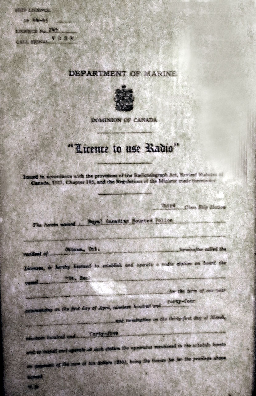
Although a bit illegible, this image will nonetheless illustrate  the format of the station licence for VGSR as issued by the Department of Marine for the year 1944-45. Click on thumbnail to enlarge. There is also an attachment with this license which authorizes transmitting frequencies and modes but it is not available for display. Also trying to figure out why the license was issued by Department of Marine instead of Department of Transport   Also missing is the signature of the authorizing Minister. Perhaps its on the attachment. An investigation continues.  (Image provided by John Guilbert)
 

John Gilbert also provides a transcript of the VGSR station licence below. 


SHIP LICENCE
1944-45
Licence No. 245
CALL SIGNAL VGSR

 DEPARTMENT OF MARINE

 DOMINION OF CANADA
“Licence to use Radio”

Issued in accordance with the provisions of the Radiotelegraph Act , Revised Statutes of Canada, 1927 Chapter [165]. and the Regulations of the Minister made thereunder Third Class Ship Station.

The herein named Royal Canadian Mounted Police Resident of Ottawa, Ont. hereinafter called the Licensee is hereby licensed to establish and operate a radio station on board the vessel “St Roch” for the term of one year commencing on the first day of April nineteen hundred and forty-four and terminating on the thirty-first day of March nineteen hundred and forty-five and to install and operate at such station the apparatus in the schedule hereto on payment of the sum of ten dollars ($10) being the licence fee for the privilege above named.

John Gilbert provides this theory as to why the Department of Marine issued the VGRS station licence for the years 1944-45 instead of the Department of Transport (DOT) .

1. Department of Marine joins the new DOT in 1935-36.
2. This is the latter part of the Great Depression and printing of new forms is a low priority compared with other things. DOT Deputy Minister Commander C P Edwards was busy trying to find the funds for the radio ranges (and buildings to house the radio ops and their families) every 100 miles across Canada;
3. When War is declared all expenditures were geared to the war effort.
4. The Halifax Office (DOT?) had old licence forms left over from pre-1936 which they had to use up before they used the new forms.
5. The St. Roch licence is made out using the old form.
6. There may be an explanation in the attachments which may be on file at  the Vancouver Marine Museum  (or even on the back of the framed licence).

PORTS-OF-CALL FOR THE ST.ROCH
This table, researched by John Gilbert,  shows the ports of-call for the St. Roch during her service life. The reports indicate that the vessel spent eleven winters in the Arctic ice,  but the list below shows twelve places where the vessel wintered over. Unless an error has been made. the exception is 1947-48 where it is believed that the ship remained in the ice but the crew were flown out. In 1999 part of the Northwest Territories was split  off to become Nunavut Territory. Maps are included for those lesser known locations.
LOCATION  WHERE  COMMENTS 
     
Esquimalt, B.C. Aa municipality at the southern tip of Vancouver Island, in British Columbia.  
Victoria, B.C.    
Vancouver, B.C.    
Dutch Harbor, Alaska Southern Aleutian Islands  
Barrow, Alaska Now called Utqiagvik. At the northernmost point of Alaska.   
Herschel Island , Yukon  An island in the Beaufort Sea (part of the Arctic Ocean), which lies 5 km (3.1 mi) off the coast of Yukon Territory This was the Regional HQ of the RCMP in the early 1930s. St. Roch wintered here  in 1947-48
Langton Bay NWT Latitude : 69 25' 00'' N
Longitude : 125 10' 00'' W
Winter quarters in 1928-29
Tree River  NWT Lat and Long unknown at this time.  Winter quarters in  1930-31, 1931-32, 1932-33, 1933-34)
Cambridge Bay, NWT A hamlet located on Victoria Island in the Kitikmeot Region of Nunavut. Now in Nunavut. Winter quarters in 1935-36, 1936-37, 1938-39, 1945-46 Operation Muskox
Walker Bay, NWT  A Canadian Arctic waterway in the Northwest 
Territories. It is on the  eastern arm of Amundsen 
Gulf. The bay is located on western Victoria Island, between Jago Bay, in the north, and Minto Inlet, in the south.
Winter quarters in 1940-41)
Pasley Bay, NWT Latitude : 70 34' 00'' N
Longitude :  96 13' 00'' W
Now in Nunavut. Winter quarters in 1941-42
Holman Island, NWT A small hamlet on the west coast of Victoria Island, Northwest Territories, Now called Ulukhaktok At.  this point, on 4 September 1944, the St. Roch received orders to proceed to Vancouver)
Pond Inlet, NWT Located in northern Baffin Island  Now in Nunavut. 
Resolution Island, NWT
Cape Hopes Advance, Quebec  (See note 1) 
 Nottingham Island, NU
Port Churchill, Manitoba (See note 2) 
*Resolution Island. Off southern tip of Baffin Island. 
*Cape Hopes Advance is located at the northwest point of      Ungava, Quebec (See note 1) 
* Nottinghaml Island is off the coast of western Baffin Island
These  were  important communications and//or navigation stations.
Halifax, N.S.    
Select this link to see four major voyages of the St. Roch.
Note 1 - Station VAY, at  Cape Hopes Advance (61°05'12.0"N 69°33'24.0"W) was established and first operated by Canadian Marconi and then by the Department of Transport. The station officially opened on July 1, 1929. Traffic consisted of weather observations, ship-shore traffic, administrative traffic and a small amount of domestic traffic that was relayed to Frobisher Bay (Iqaluit) via a point-to-point circuit using telegraphy. Nottingham Island, Fort Chimo and Clyde River also communicated with Frobisher on that circuit. The station was closed at the end of the 1970 Arctic shipping season.

Note 2- A coastal station at Churchill, likely opened in 1928, was initially assigned call sign VBY, later changing to VAP by 1935. It  may have opened its doors  at Fort Churchill, about 3 miles southeast of the Town of Churchill. It was used as  a coastal  station for only a few months in summer when ships sailed into Churchill to pick up a load of grain.  A coastal  station operator may have been sent to Churchill to  operate the station for the short period  that it was required. VAP Port Churchill became a combined Marine Aeradio station and also an International Aeradio Station. The Marine portion monitored 500 kHz and had a working frequency of 420 kHz. The radio telephone portion monitored the distress frequency  of 2182 kHz and a working frequency 2582 kHz. Also monitored were the VHF frequencies of  161.60, 156.80 and 161.90 MHz. Towards the end, when the Aeradio portion of the station separated from the Marine portion, the marine portion of VAP was remotely operated from  VBA in Thunder Bay,,  Ontario. At some later tine, VBY was assigned to the Canadian Marconi Company in Lunenburg N.S. 


Credits and References::

1) ITU Ships Listings 1930 and 1933 editions
2) THE ANNUAL REPORTS OF THE RADIO DIVISION,  DEPARTMENT OF TRANSPORT 1936-1942
3) John Gilbert <jgilbert(at)ca.inter.net>
4) Cape Hopes Advance   http://www.2182.ca/en/history/capehopesadvance.html

Back to St. Roch

Dec 2979