CHURCHILL PHOTO ALBUM - TRANSMITTING FACILITIES
By 1956, it became very apparent that there was an operational requirement for reliable point-to-point communications between HMCS Churchill, NRS Aklavik and NRS Frobisher Bay. Due to Arctic conditions, distance, and the lack of any other method of reliable communications, meant that three HF radio links had to be established.

In April 1956, Cdr. H.A. Porter, Director of Naval Communications, sent a memorandum to ACNS (Acting Chief of Naval Staff and VCNS (Vice Chief of Naval Staff) requesting reliable communications between these stations. Here is a summary of Cdr. Porter's report.
 

"The growing importance of Aklavik in the SRA (Supplementary Radio Activities) operational field necessitated setting up a radio circuit between Aklavik and Churchill which is at present is carrying increased loads of traffic. The existing transmitters, namely type TH58, were purchased on an "emergency" basis at the commencement of the Korean War are both inadequate in terms of power output and capacity.

It is proposed to replace the existing TH58 transmitter in Churchill with one of modern design with increased capacity and power. It is not proposed to replace the one in Aklavik until that station moves to Inuvik. The present TH58 transmitter at Churchill only has a power output of 1 kw. Owing to the distances involved and to propagation conditions in the north, this  transmitter often proves to have insufficient power for reliable communications. The operational functions of Aklavik , Frobisher and Churchill require constant and reliable point-to-point communications.  The existing transmitter does not permit simultaneous transmissions on a number of frequencies, therefore it does not meet all requirements. Furthermore, it frequently breaks down  and spare parts are no longer manufactured  thus posing a serious maintenance problem.

The northern commitments of Canadian and US Ships including support of the DEW line have produced a requirement to use Churchill as a communication link. Present transmitting facilities are not capable of communicating with Aklavik, Frobisher Bay and the ships at sea simultaneously.

Under consideration as a replacement transmitter, is the Westinghouse Model MW with a 3 kw power output. It can be keyed simultaneously or independently on up to four channels and is considered ideal for the purpose envisioned. If approved, it is proposed to install it in the new RCAF transmitter building planned for the completion  in the summer of 1956.

In March 1955, Naval Staff approved , in principle the purchase of a replacement transmitter for Churchill at a cost of $35,000 (Ed- This would translate to $284,000 in 2010) . Funds in this amount appear in the final 1956-57 Estimates Book under Equipment Project No. 75, Priority "A". "

On 25th April 1956, the Naval Board approved the procurement of one MW transmitter for Churchill.
According to Chief Omer LeVasseur, the MW transmitter fed a rhombic antenna. This rhombic had a huge terminating resistor – about a foot long – which was inside a protective enclosure. It was located at the common Canadian/US transmitting complex sometimes referred to as the Alternate Transmitting site. The RCN only had one rhombic here with the remainder of the antennas being RCAF.

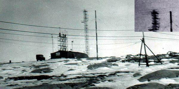
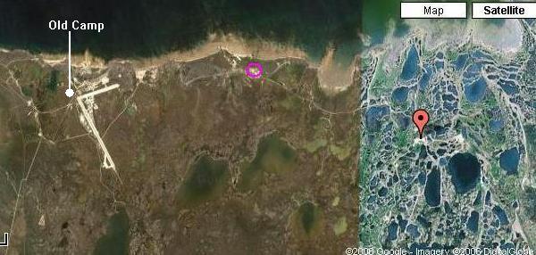
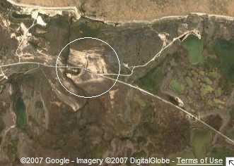
Another transmitter, the Canadian Marconi TH-58, was used for Churchill/Frobisher operations on occasion. It was located in a shed-like structure not far from the base hospital in the camp at Fort Churchill and sometimes referred to as Old Camp. This transmitter was lacking its protective skins  - just a chassis with the tubes and components showing".
 

church_radiostation1959.jpg
This photo, dating from 1959, is believed to be the common Canadian/US transmitting complex which supported the Navy, RCAF, RC Sigs and USAF. Note the 3 element beam atop the tower in the enhanced inset photo. There were many problems with polar bears at this site which certainly complicated life for the technicians who serviced the equipment and antennas. (Photo via Eileen Jacob/Steve Hutchens)

Although everyone was aware of the USAF involvement with the Churchill rocket range, little was known of their detachment of in-flight refuelling aircraft in support of their strike and surveillance aircraft flying the Polar Route. That detachment was deployed on the south side of the airport and out of sight. Whenever photos of the Fort Churchill complex are shown, there is never any indication that the detachment existed. 


church_alt_trans_site1.jpg
While he was a youth, Ian MacPherson's father worked at a facility known as the Alternate Transmitting Site which is marked with a purple circle. That was the actual name on the sign. This has now been related to the term "Canadian/US transmitting complex". It was 6 miles distant from the Churchill Operations building.  A red  marker denotes the  the Churchill rocket range launch pad which was 24 km from the Town of Churchill. The pad is located at 58°44'3" N, 93°49'13" W. (Image courtesy Google Maps)
church_alt_trans_site2.jpg
This is closer view of the Alternate Transmitting site and it appears something is still active there in 2006 since two buildings are visible along with a radial counterpoise. Unfortunately Google's watermark is right over the convergence point of the radials so it's hard to tell what's there. (Image courtesy Google Maps)
church_alt_trans_site3.jpg
The closest view reveals three towers, with the tallest one appearing to be twice the height of the shorter ones. There are three more towers out of view beyond the upper left corner of the image.
Radio towers are never left abandoned so that confirms this location is still used for some purpose. What is this site used for today? (Image courtesy Google Maps)
The Canadian Coast Guard operates a site in Churchill at 58° 45' 42"N,  93° 56' 39" W.  These co-ordinates place it within the Alternate Transmitting site boundaries. It is a satellite of VBA Thunder Bay Radio and operates during the navigation season, normally July 1 to October 31.

Frequencies in use:
Transmit                    Receive
2182                            2182
2582                            2206
4375                            4083

VHF Channel 16 (156.8 MHz) and Channel 26 (Duplex). Details are in Radio Aids to Marine Navigation (RAMN) revised yearly.

church_animal_illusion.jpg
From a satellite image, the Alternate Transmitting Site looks link the head of a bear or wolf with the road running right into its mouth. (Image courtesy Google Maps)


This is an orphaned document dated April 16/58 which is part of some Appendix A. It appears this drawing is referring to the Churchill Joint Services transmitting site since there was no transmitting building at HMCS Churchill itself.

1) The notations such as P14(TO) -1 appear to be designators for radio circuits. Is there is any rhyme or reason to the designator format? 
2) It is assumed  thar those numerous circles are masts which support transmission lines. Correct? 
3) If 2 is correct, there appear to be three transmission lines leaving the transmitting building and somehow they slit into five. Can anyone explain this? 
4) Why are the two transmission lines on the left side thicker than others on the drawing?
5) It is assumed that  the rectangular shaped objects in the upper right and lower left quadrants to be the actual antennas themselves. What exactly are these rectangles? In the upper right, the rectangular shaped objects appear to be supported by 10 guy wires but it’s a totally different arrangement in the lower left. 

If anyone has answers to the the above questions, contact: jerry.proc@sympatico.ca

CHESNAYE  TRANSMITTING STATION

In 1950, two parcels of land, collectively 4419 acres in size,  were transferred from the Department of Transport to the Department of National Defense at mileage 467.32 of the Hudson Bay Railway. The intent was to use the site for a proposed Joint Service Transmitting station. After the transfer, the property was allocated to the custodial care of the RCN.  The new station, named the Chesnaye Transmitting Station was located 42 miles south of Fort Churchill and approximately 7 miles east of the main Canadian National Railways line. A few clues suggest that this site was within the Churchill rocket range, but it is hard to believe that the rocket range extended so far south considering that the Town of Churchill was only so 24 km (15 miles) due west of the launch pad at 58°44'3" N, 93°49'13" W.

Four buildings were  constructed on a prominent sand ridge shaped roughly as a vee and pointed north west. The legs of the vee are approximately 3 miles in length, with the structures being situated at the point of the vee. This ridge was about 50 to 60 feet higher than the surrounding countryside. There was a rail spur line to the site originally but it had been ripped out only leaving the right of way. For reasons unknown at this time, the project was subsequently abandoned after the structures were erected.

church_chesnaye_location.jpg
This map shows the relative positions of the abandoned  site relative to Churchill -1. Chesnaye  2. Navy Buildings  3. HMCS Churchill. (Drawing courtesy National Archives. Submitted by Joe Costello)
In a letter [1] dated January 6, 1960, the Naval Secretary wrote to the Chief of Staff outlying the situation at the Chesnaye site. This letter  was prompted because the Secretary Treasurer of the Grace Church in Churchill requested that the buildings be leased to the church for use as a Summer Bible Camp. The Navy wanted to know if the Army had any use for the property before proceeding any further since the Navy contemplated leasing the the structures and a small parcel of land for a ten year period. A month later, the response from Army headquarters indicated that they had no use for the site, however, they would not concur in having the land leased to the Grace Church because the property was located within the Churchill rocket range.

Over a year later, on March 8, 1961, the Board of Officers convened at Fort Churchill to discuss the handover of the land and buildings at the Chesnaye Transmitting station from the RCN to the Canadian Army and see if there was any other use for the property. There was no conclusive outcome [2] from this meeting other than to say that the buildings could be placed in long term storage for an expenditure of $2,000. There was also the problem of accessibility since the site could only be reached by helicopter or snow vehicles unless a road and four bridges were constructed [2]. It is most puzzling as to why the rail line was removed since this entailed a major expense. In all of this, would anyone know why the Joint Service Transmitting site was built so far from Fort Churchill and HMCS Churchill in the first place?

Today, the Wat'chee Lodge occupies the property where the proposed transmitting site was to be. Chesnaye is now an unmanned rail stop in the VIA rail network and the usual way to get to the Lodge.

WHAT IS THIS SITE ?

church_tx_bldg.jpg
This planning drawing from 1949 indicates a square labelled "transmitter building". Its position has been transferred to the satellite image below as Site 'A'. In a 1947 planning drawing , this location is referred to "abandoned transmitter site".  (Image courtesy National Archives via Joe Costello) 

 
church_tx site_speculative.jpg
From the planning drawing,  the square representing the  "transmitter building" has been marked as Site 'A' in this satellite image. Over the years, whatever was installed here grew in size as evidenced by the presence of Site 'B'.  A comparison between a 1965 photo of site A and B ( below ) and an enlargement of the satellite image suggests that these two sites are still active. Can anyone confirm the useage for these sites in 1965 and today? (Image courtesy Google Maps)

 
church_txsiteab_enlarg.jpg
An enlargement of sites 'A' and 'B' taken in 1965 show a number of masts coloured in green. Is this site part of Churchill airport? (Enlargement of NAPL Photo A19351-27)

FOOTNOTES

1. Naval Secretary's Letter File # 9650-161-1
2. Proceedings of the Board of Officers  #5425-C185/55


Credits and References:

1) Joe Costello, Web master RC Sigs web site: joe(at)rcsigs.ca
2) Ian MacPherson <Quailend(at)shaw.ca>
3) Gord Walker <walker6(at)sympatico.ca>
4) Ray White <legerwhite(at)gmail.com>

Back to HMCS Churchill
Feb 8/11