| INTRODUCTION
|
| INTRODUCTION
|
HISTORYNorthwest Staging Route
The growth of air travel in the 1930's sparked an interest in creating a "Great Circle Route", to link the Canadian Northwest with Alaska, Siberia, and China. In 1935, the Canadian Department of Transport sponsored Dan McLean and the famous bush pilot, Punch Dickens, to scout an air route to the Far East. Based on their recommendations, the federal government authorized the construction of airfields between Edmonton, Alberta and Whitehorse, Yukon Territory, as the start of a route to the Orient. In 1940, work began on airfields at Grande Prairie, Alberta; Fort St. John and Fort Nelson, British Columbia; and Watson Lake and Whitehorse in the Yukon.
Between these points, emergency airstrips were built as a safety measure. This included landing fields at 100 mile intervals and radio ranging stations at 200 mile intervals. By September 1941, the route was open to aircraft flying visual flight rules. Three months later, the installation of radio beacons made all-weather flying possible.
After the Japanese attack on Pearl Harbor on December 7, 1941, the United States government was concerned that the transport of troops, equipment and supplies on the Pacific route was vulnerable to attack. Alaska also provided ground access to a series of airports that had been built to transport supplies to Russia. As a result, the protection of the Northwest Staging Route became of paramount importance.
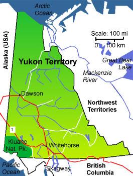
Location of Whitehorse. (Map courtesy Moving In Canada) From 1939 to September 1942, the federal Department of Transport controlled the air operations of the Northwest Staging Route. In 1942, it was handed over to the Royal Canadian Air Force because the route was being used predominantly for military purposes. RCAF Works and Building staff were located at each main aerodrome. About 450 aircraft per month traversed the route by 1943. In June 1944, the Northwest Air Command was formed to take over complete operations of the route with headquarters in Edmonton. The Yukon section of the Northwest Air Command was RCAF Station Whitehorse, with detachments at Teslin, Aishihik, and Snag. In 1946, a unit at Watson Lake was added.
After World War II, the RCAF controlled the airports along the staging route, provided aircraft in Whitehorse for search and rescue operations, and transported people, freight and mail for the Dominion of Canada. RCAF Station Whitehorse continued to function primarily as a refueling point to Alaska. In 1948, the radio station at Prince Rupert, BC closed so the intercept positions were moved to Whitehorse. Initially, there were 5 operators on shift. By 1956, twenty-three operators per shift were working four days, four evenings, four midnights with four days off [1]. Since the RCAF had no separate trade classification for the job of Intercept Operator, all training was done locally at the station.
The Department of Transport took over the operation and maintenance of the airport facilities at Whitehorse in 1958 while the RCAFs function changed to primarily a Radio Unit [2], specializing in communications [3]. There were no DF operations at this station, just intercept. Earle "Smitty" Smith, VE6NM, first arrived in Whitehorse in 1954. He does not recall any radio transmissions from the site since the station's "output" was sent via CN Telecommunications (CNT) and later by a microwave system built by RCA and operated by CNT. [4]
Earle Smith provides recalls some early personnel exchanges. "A group of RCAF Ops including myself from 5RadU left Whitehorse late August 1957 bound for HMCS Gloucester, Ottawa, for Arctic training and to get to know our RCN counterparts who would work at Alert with us. Another group went to Resolute with an Army Sigs group. We arrived in Alert in the first part of September 1957 and did our six month tour of duty. We were happy to be rotated out. Both the Alert and Resolute crews were replaced by more RCAF and Army crews in an 1958 exchange. Whitehorse was still exchanging operators when I transferred out of 5RadU in 1961".
Jim Thoreson expands on this. "I was transferred to Alert in January 1962 for a six month stint and I think our contingent of nine men were the second batch to go up after a long dry spell but then they continued sending them for quite a while after that."
In the 1962 time frame, there was an exchange of RC Sigs personnel from Ladner and RCAF personnel from Whitehorse. Twenty personnel from each station were involved in the exchange. By March 1964 the RCAF had a strength of over 51,000 of whom 1,200 were airwomen, many serving in the Telecommunications Branch.[5]
Whitehorse became a SUPRAD (SUPplementary RADdio system) station in 1966 as did Ladner as a result of the Canadian Forces Unification. Whitehorse was Air Force until Unification, then it became Canadian Forces. All operators were mostly RCAF but all new training was done at Gloucester under SUPRAD. In 1966, RCAF Flin Flon, Manitoba also became part of SUPRAD not because it was an intercept station because Ottawa did not know what other organizational umbrella to place it under.
This high level satellite photo shows the relative location the former 5RadU relative to the Town of Whitehorse and the airport. The Ops building is positioned precisely at 60° 41' 2.73"N , 135° 4' 46.57"W. (Photo courtesy Google Earth) This satellite image, taken in 2007, shows the former 5RadU Operations facility. The building at the left with the dark roof was the actual Ops building while the structure with the light blue roof was the Guardroom and Admin area. It was linked to the two story Ops Building by a walkway. Today (2007), the land surrounding the former base is occupied by the Lobird Trailer Court. The former Ops Building and Guardhouse have been converted to other uses and serve the local inhabitants. (Photo courtesy Google Earth) A very closeup view of the ex-5RadU Operations Building. (Photo courtesy Google Earth) RADIO OPERATIONS
In the mid 50's, Whitehorse used one or two banks of Baudot teleprinters to copy incoming traffic. There were the usual antenna multicoupler panels as well. The shift NCO was in charge of these and would make the appropriate selection whenever operators would call for a different rhombic antenna. Radio Finger Printing (RFP) was practiced at the station, however some of the operators did not like to use the equipment for some strange reason.
Since Whitehorse was an intercept-only station, it did not have a DF component. The station's "output" was sent out via encrypted landline from the Comcentre. Because of that, there was no need to send anything over the air. Consequentially, to the best of anyone's recollection, the station did not have an assigned radio call sign.
This is the 5RadU Operations site In this photo, the objects which look like the Star of David are actually plexiglass antenna spreaders used with the wire cage dipoles sometimes referred to as "fat dipoles". Click on thumbnail to enlarge. The date of the photo is unknown at this time. All the antennas in the photo were receive-only. There were no radio transmitters in the Ops Building. (Photo source unknown. Presumed to be DND)
This is 6-conductor wire cage dipole in a compressed view. Each arm of the dipole consists of six conductors separated by spreaders. For each arm, the conductors at both ends are bonded electrically. It's then fed like a regular dipole. The main feature of this antenna is the broadband characteristic and lower SWR when compared to its single conductor cousins. (Graphic courtesy Broadband Dipoles site) .
SOME OF THE EQUIPMENT USED AT WHITEHORSE
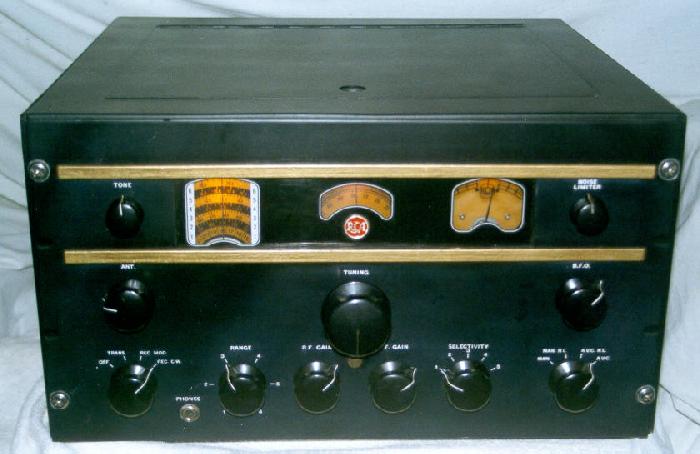
Click to enlargeRCA AR-88 receiver . The 'D' version of the receiver covered 535 KHz to 32 MHz. The RCAF purchased AR88's from RCA under the designator AR-88/GR-17. (Courtesy Ray Robinson Communication Museum) SP-600. By 1954, all the RCA AR-88's had been replaced by the Hammarlund SP-600 receiver .Coverage: 0.54 MHz to 54 MHz, in six bands. SP600's were produced between 1950 and 1972. Cost was $985 in 1950. (Image courtesy Kurrarjong Radio Museum) Racal RA-17. Tuning range is 0.5 to 30 MHz in thirty 1 MHz bands. These entered service with the Canadian military in the early 60's. (Photo courtesy radio@ozemaol.com.au) Rhombics. Three wire, "Curtain" rhombics were used at Whitehorse. In RCAF parlance these were called "three bay" rhombics because of the way the three wires were supported on the side masts - one above another. The additional conductors used in this type of antenna broaden its bandwidth.. Earle Smith recalls the following. "Our arrays of rhombics covered from the ENE to WNW in two ranges It is also possible there was an outer semi circle of rhombics, for a different frequency band, but covering the same azimuths". Can anyone confirm? (Graphic courtesy KB1SG's Rhombic Pages) CLOSURE
The 1966 white paper Supplementary Radio Activities Consolidation Plan stated that the operational value of Whitehorse and Churchill has diminished with the development of Alert and Inuvik to the extent that their product is now of marginal value only. It was recommended to close down Whitehorse. That would result in the saving of $2,809,000 per annum. Personnel and equipment from Whitehorse, Churchill and Vancouver (also recommended for closing) would be redeployed to Ottawa and Inuvik. In 1968, CFS Whitehorse stood down, thus ending a presence of almost 30 years in the Yukon.
WHITEHORSE PHOTOS Radio Operations Low Level Aerials Stories Memorabilia Other NOTES:
[1] Quoted from "History of Canadian Signals Intelligence".
[2] Most of the radar stations established in Canada during World War II were initially identified as "Radio Detachments" (RD). This terminology was changed to "Radio Units" (RU) in September 1944. It would appear that the new term was also extended to cover radio operations.
[3] The fact that Whitehorse was always an intercept station right from 1948 onwards was confirmed in an 1985 correspondence exchange between Earle Smith and F/L MacDonald, the Officer-in-Charge of the radio site. RCAF Station Whitehorse (the host unit) had a Wing commander as a CO.
[4] On 25 March 1959, Canadian National Telecommunications was awarded a contract by the United States Department of Defence to build a microwave radio system from Grand Prairie Alberta to the Alaska border to meet US military defence of North America requirements.
[5] Quoted from http://www.commelec.forces.gc.ca/organization/history/branch/chap6_e.asp
Credits and References:1) Earle Smith - VE6NM <ve6nm(at)rac.ca>
2) Alaska Highway Archives http://www.alaskahighwayarchives.ca/en/chap4/4routercairforce.php
3) Whitehorse badge courtesy Webshots web page.
4) History of Whitehorse http://www.yukonalaska.com/communities/whitehorsehist.html
5) Bruce Forsyth's Canadian Military History Page http://www.geocities.com/Pentagon/Quarters/2529/
6) SUPPLEMENTARY RADIO ACTIVITIES CONSOLIDATION PLAN. A presentation given by DIO to Defence Council on 30 May 66.
7) Lynn Wortman <lynn.wortman@rogers.com>
8) Radio Detachments http://www.pinetreeline.org/misc/other/misc5b3.html
9) Personnel exchange - http://www.rcsigs.ca/ViewItem/1083/
10) Yukon Map http://www.movingincanada.com/yukon/Yukon-map.jpg
11) Broadband Dipoles site http://www.ee.surrey.ac.uk/Personal/D.Jefferies/antennexarticles/bbd.htm
12) History of Canadian Signals Intelligence and Direction Finding by Lynn Wortman and George Fraser
13) Ray Robinson Communications Museum http://www.ling.mq.edu.au/~robinson/museum/ar88.html
14) Kurrajong Radio Museum http://vk2bv.org/museum/index.htm
15) RA17 photo http://members.ozemail.com.au/~radio/ra17.html
16) Bob Wolstenholme <wolsten(at)telusplanet.net>
17) Sherron Jones <sherronjones@shaw.ca>
18) KB1SG's Rhombic Pages http://www.mapability.com/ei8ic/index.html?http&&&www.mapability.com/ei8ic/rhombic/text.html
19) Microwave system reference http://www.commelec.forces.gc.ca/organization/history/branch/chap6_e.asp
20) NWSR http://www.airforce.forces.ca/airfield_engineers/history/history_2_e.htm
21) The Canadian Encyclopedia http://thecanadianencyclopedia.com/index.cfm?PgNm=TCE&Params=A1ARTA0005817
22) Jim Thoreson <jimthoreson(at)shaw.ca>Jan 2/18
 Originally
opened by the Department of Transport, Whitehorse airfield was transferred
to the Royal Canadian Air Force in 1942 as part of the system called the
Northwest Staging Route. Designated as RCAF Station Whitehorse, it had
detachments at Teslin, Aishihik, and Snag and in 1946, at Watson Lake.
After World War II, RCAF Station Whitehorse continued to function primarily
as a refueling point on the Alaska route. The Department of Transport took
over the operation of the airport, but the RCAF remained. In 1948,
the station at Prince Rupert closed and the intercept positions were moved
to Whitehorse. The station's function changed to primarily a Radio Unit,
namely, No. 5 Radio Unit. It became part of the Canadian Forces Supplementary
Radio System in 1966 and was renamed Canadian Forces Station Whitehorse.
It was short lived operation as CFS Whitehorse closed in 1968. The station's
motto "Verbum Expedimus" means "Unfold the Word" (Break the
Code).
Originally
opened by the Department of Transport, Whitehorse airfield was transferred
to the Royal Canadian Air Force in 1942 as part of the system called the
Northwest Staging Route. Designated as RCAF Station Whitehorse, it had
detachments at Teslin, Aishihik, and Snag and in 1946, at Watson Lake.
After World War II, RCAF Station Whitehorse continued to function primarily
as a refueling point on the Alaska route. The Department of Transport took
over the operation of the airport, but the RCAF remained. In 1948,
the station at Prince Rupert closed and the intercept positions were moved
to Whitehorse. The station's function changed to primarily a Radio Unit,
namely, No. 5 Radio Unit. It became part of the Canadian Forces Supplementary
Radio System in 1966 and was renamed Canadian Forces Station Whitehorse.
It was short lived operation as CFS Whitehorse closed in 1968. The station's
motto "Verbum Expedimus" means "Unfold the Word" (Break the
Code).