Inuvik
INTRODUCTION
 Naval Radio Station (NRS) Inuvik CFV was established in the Northwest
Territories in 1961 as a result of the move of NRS Aklavik. On 10 September
1963, the site was commissioned and became HMCS Inuvik. As a result of
the Armed Forces Unification, the station was renamed CFS Inuvik in 1966.
In the Inuvialuktun dialect, the town of Inuvik means "Place of Man"
and it was the first model town in the Canadian Arctic when it was built
between 1956 to 1962.
Naval Radio Station (NRS) Inuvik CFV was established in the Northwest
Territories in 1961 as a result of the move of NRS Aklavik. On 10 September
1963, the site was commissioned and became HMCS Inuvik. As a result of
the Armed Forces Unification, the station was renamed CFS Inuvik in 1966.
In the Inuvialuktun dialect, the town of Inuvik means "Place of Man"
and it was the first model town in the Canadian Arctic when it was built
between 1956 to 1962.
BADGE Blazon: Party per pale Sable and Or, the figure of an Eskimo
in native garb, Argent, embellished Azure, his back affronts and launching
with his dexter arm a lightning flash Gules.
Badge Significance: The black and yellow background is symbolic of the
long, seasonal Arctic nights and days. The Eskimo is used here in reference
to the meaning of the word "Inuvik" - The Place of Man - or The Place Where
Man Is. He is shown in the act of hurling a flash of lightning as a reference
to Naval Communications.
Ship's Colours: Yellow and Black. |
LOCATION
 |
| The Town of Inuvik, 68º 21'N Longitude: 133º 43' W, was located
on the east side of the Mackenzie River delta, 97 km south of the Beaufort
Sea. It was approximately 75 miles distant from Aklavik.
(Map courtesy
of Multimap.com) |
HISTORY
Aklavik East-3 was designated as the future seat of government for the
Mackenzie Delta and all the federal offices of the RCMP, Northern Affairs,
NCPC (Northern Canada Power Corporation), DOT, DPW, as well as National
Defence (RCN and RCCS - NWT and Yukon Radio System) were scheduled
to be administered from East-3, which later became known as Inuvik. In
June 1957 the last station to join the NWT&Y, Aklavik East Three, was
opened by Corporal Peter Grey of the RC Sigs. Although Inuvik was primarily
a "government" town, a large percent of its population were trappers,
miners, and private entrepreneurs.
Although Aklavik grew to be a moderately settled town by the early 1950s,
it's restricted waterways and instability of the silt and permafrost terrain
were considered by experts as inadequate for any new construction. Because
of this, the Department of Northern Affairs and National Resources started
to plan the move to a new site on higher ground as early as November 1954
with construction commencing in 1956. The new site was called Aklavik East
Three[1] but was always referred to as East 3 and later renamed to Inuvik.
The "Welcome to Inuvik", booklet issued to all new arrivals, provides
details about the move from Aklavik to Inuvik.
"Late in February 1961, a tractor train of four sleds started
on a journey from Aklavik that would follow the frozen channels and branches
of the Mackenzie River, the north's winter highway. Labouring under the
heavy load, the train would arrive at Inuvik in slightly less than three
days. This journey was one of the final steps in the several stages of
the transfer of the old naval station Aklavik to new Inuvik.
Early in November 1960, the Royal Canadian Navy took over the complex
of buildings comprising the new naval radio station from the contractors.
This included an Administration/Accommodation building located in the settlement,
an Operations building 4 miles to the north, a Transmitter building 7 miles
to the south, a six-bay garage and an assortment of warehouse and stores
facilities. An advance party of four men with a Petty Officer in charge
was immediately dispatched from Aklavik to take possession and maintain
a boiler and fire watch until arrangements for the move could be actually
implemented.
Although the buildings were new, the advance party was not without problems.
Frozen pipes, defective circulating pumps, fuel oil too cold to circulate,
jury-rigged oil tanks, malfunctions in the fire protection system
as well as continuing difficulties with transportation were among some
of the immediate hazards and problems. Progressively, the advance party
was expanded to include a cook, storesmen, technicians and working hands.
The task of erecting antenna, installing transmitters and consoles, interior
wiring of the Operations facility, along with the storing and fitting out
of the buildings, gathered momentum, bringing the date of the long awaited
move closer to reality.
The move took place during the latter part of March 1961. Prior to this,
many items were transferred well in advance - spare parts, furniture, equipment,
stationary, provisions and an endless list of stores that could be spared
from the day-to-day requirements in Aklavik. The intervening 75 miles of
frozen waterways to Inuvik became a well-worn path as tractor, snowmobile,
and sleds drawn by muskeg tractors gradually moved supplies.
From the south, the RCAF entered their support with Hercules and Boxcar
aircraft hauling the stores and furnishings required to complete the fitting
out of the new station and the 42 Permanent Married Quarters. A ½
ton jeep, also included in the airlifts, helped to alleviate the transportation
situation. In sub-zero temperatures ranging between 30F and 40F, several
hundred tons of stores were moved without incident.
The final transfer began on the 17th and 18th of March as the families,
belongings, and personnel who could be spared were airlifted by a Pacific
Western Airways Otter aircraft to their new home. On the 19th, the remainder
of the complement with the exception of a de-storing party of five and
their equipment, flew to Inuvik completing a total of eighteen flights
transporting more than 100 personnel and their baggage in a three-day period.
With all personnel pitching in, Naval Radio Station Inuvik was made operational
at 00001Z on the 20th of March, l961, a credit to the hard work and co-operation
of all personnel.
To those from Aklavik who had endured the limited conveniences and humble
luxuries of isolation, Inuvik was a return to civilization. This new town
of the North provided all those things lacking in Aklavik - a modern school
for more than 700 pupils, an 80 bed hospital, central heating, water, sewage,
modern and fully equipped houses and apartments".
Ray White provides this recollection when the town of Inuvik was officially
inaugurated in July 1961 by the Prime Minister, Rt. Hon John G. Diefenbaker.
"He visited the Administration section of the Navy Base in downtown Inuvik
and also paid a visit to the Operations site. The CO, the Operations
Officer, and the Operations Chief were with him when he toured the main
operations room. None of his Diefenbaker's assistants or staff were
allowed into the secure area. I was Watch Supervisor at the time
and answered a number of very knowledgeable questions posed by Mr. Diefenbaker,
who also regaled us with anecdotal stories about Nikita Khrushchevs heavy
drinking problems at the time."
In 1962, RAdm P. D. Budge, visited NRS Inuvik on his final tour as Chief
of Naval Personnel. On this occasion, Ceremonial Divisions were held in
the gymnasium of Sir Alexander Mackenzie School in Inuvik. This ceremonial
occasion was attended by all personnel except those on duty at the Operations
site. It was a memorable occasion for those rates who had served with Admiral
Budge, a significant figure in the history of the RCN. Many dependents,
other civilians, and students of the school were also present.
Gary King was stationed at Inuvik from September 1961 to June 1962 .
He recalls the visit of Admiral Budge. "At that time there was a cook by
the name of AB Penney. He was much more than a cook and his talents
were certainly wasted except when Admiral Budge showed up.
I recall that Penney made three things that were memorable for the dinner
for the Admiral.
1. Tomato juice glasses arranged as a fouled anchor
2. A salmon salad rearranged to look once again like a fish - it was
amazing.
3. A 'Baked Alaskan' made in the shape of an igloo.
Regarding the latter - the Admiral wouldn't touch because it looked
too good to eat so he sent it to the school as a treat for the kids.
Ray White knew AB Penney well. "He was an ABCK1, first name Alan,
and was part of the complement of Aklavik that moved over to the new station
at Inuvik. He was (is) a superb cook and he made life a lot more
liveable in the north, a noteworthy achievement when one considers the
limitations on rations available. In his off time he provided catering
services to the Officers' Wardroom and the Chiefs and POs Mess and it was
always a delight to partake of his goodies. Alan was a West Coast
rating and his culinary reputation is said to have preceded him to his
various postings. Even on ordinary duty days in the galley, he was invariably
dressed like a chef in a fine restaurant. A great boost for Aklavik's and
Inuvik's morale".
An 1964 issue of Crowsnest magazine (Vol. 16, No 3 and 4) describes
Inuvik's comissioning ceremonies.
"On September 10, 1963 a comissioning ceremony was held in
front of the Naval Administration Building on Distributor Street and was
witnessed by most of the 850 pupils of Sir Alexander Mackenzie School,
who were released from class to view this event. Several hundred townspeople
turned out for the occasion as well.
The guest of honour was Rear-Admiral M.G. Stirling, Chief of Naval Personnel,
who was visiting Inuvik in the course of the annual tour of supplementary
radio stations. His entourage included Captain A. O. Solomon, Naval Secretary;
Surgeon Captain F. G. MacHattie, representing the Surgeon-General;
Cdr. P. J. Pratley, Director Supplementary Radio Activities, and Cdr. B.E.
Gaynor, representing the Director General of Naval Supply.
The ceremony was under the direction of the commanding officer, Lt.-Cdr.
D. W. Smith, and the religious portions were presided over by the Rt. Rev.
Henry G. Cook, suffragan Bishop of the Arctic, of All Saints Pro-Cathedral,
Aklavik; Rev. Fr. Adam, OMI, pastor of the Church of Our Lady of Victory,
Inuvik, and Rev. A. G. Morton, Protestant officiating clergyman for HMCS
Inuvik, of the Church of the Ascension, Inuvik. Admiral Stirling addressed
the assembly and briefly reviewed the history of the Western Arctic, paying
tribute to the naval and civilian explorers who penetrated the north in
the early days of Canada. After he had inspected the ship's company, Rear-Admiral
Stirling made rounds of the naval buildings.
To commemorate the commissioning, a medallion
was designed bearing the ship's badge on the obverse and a map of the Mackenzie
Delta on the reverse. This was struck in the same diameter as a Canadian
silver dollar in bronze, silver metal, sterling silver and goldplated sterling
silver. A limited number of bronze copies of the medallion were available
to naval personnel from the ship's canteen, HMCS Inuvik, for $2 ".
 |
| The circle denotes the RCN's Administrative Building in Inuvik in this
early 1960's photo. The white pipelines in the upper central and left portion
of the photo are called "utilidors". These are insulated ducts that distribute
steam, hot/cold water to the buildings and also carry waste away. The view
is roughly to the northwest (Photo courtesy Northern Affairs submitted
by Eric Earl) |
After the town of Inuvik was established, the CBC took over
radio station CHAK in Alkavik, raised the power to 1 kilowatt and changed
the frequency to 860 kHz. One of the operators hired by the CBC was
Nellie Hvatum, who later married Russ Cournoyea (pronounced Korn-yay),
a Communications Supplementary rate, now deceased. Nellie went on to become
CEO of a corporation worth more than $300 million dollars and also became
the first Premier of the NWT. Her hands-on grass-roots, leadership
style kept her in charge of the Northwest Territories for close to three
decades.
Ray White relates this story. "In Inuvik, a civilian entrepreneur, Bruno
Weideman, who ran the only taxi service in town, would make a watch-change
run around the PMQ's and barracks and pick up the watch-keepers.
In winter, he used a Bombardier snowmobile. (In those days it was pronounced
Bom-ba-deer). Mr Weideman was a German immigrant to Canada, having arrived
in the late 1930's. There was a story in Aklavik about him coming in to
Peffer's Hotel one day during the London Blitz and announcing that he had
been listening to the shortwave and had heard that the German Luftwaffe
had really given it to the English. Needless to say he was not very popular
around town for this".
 |
| Inuvik Administration Building from 1961
to 1968. (DND file photo) |
BASE DESCRIPTION AND BADGE
Gerry Burton describes the town while he served there in 1959. "If you
look at the town site as a "T" with a very long top you might imagine the
following: The shank of the "T" ran from the river approximately
1 km with the power plant on the right and the Navy Administration Building
and living quarters on the left. The RCMP Building and radio station
CHAK were also along this road. At the top of this road, if you turned
left, you went past the Hudson Bay Company and you would eventually come
to the Navy Ops Building which was about 5 km out of town and the end of
the road. On the other hand, if you turned right, went out of town
past the hospital for about for about 3 km you would come to the Navy Transmitter
Building which was about 1 km before the Airport".
Invuik started as a tender to GLOUCESTER, as did Aklavik, Gander,
Frobisher Bay, Masset, Bermuda and in its day, Chimo. None of them had
an official badge, at least as tenders. Gloucester provided all the administrative
functions, pay etc, in its capacity as home to the Senior Officer, Supplementary
Radio System (SOSRS). In actual fact, SOSRS was also the Commanding
Officer of HMC NRS Gloucester which became HMCS Gloucester sometime
around 1956. The badge depicted at the top of this document was the station's
badge as a Canadian Forces Station. Select this
link to see an image of the badge approved by Queen Elizabeth II and
the Director of Ceremonial in 1972. (Image courtesy of Ray White)
SUPRAD stations (Supplementary Radio Activities) were given the cover
"Search And Rescue". John Murison, a former CS rate (Communicator
Supplementary)
, explains. "Search and Rescue was our cover. If there were any personnel
on the same base who were not from our branch and asked what our
duties were, we said "Search and Rescue". This happened at any base that
I served in and my answer had to be the same even when I was
home on leave. Our work was Intelligence. Any one who didn't know that
should have".
(Click to Enlarge)
THE 1968 FIRE
The book "History of Canadian Signals Intelligence and Direction
Finding" provides a good account of the life threatening fire which
occurred in 1968. Since it was not possible to contain the fire, all efforts
went into saving the Operations Building.
"On August 10, 1968, a small kids camp fire between the airport
and the town site, quickly erupted into a blaze that devoured trees and
tundra.. The fire raced north, past the town, and headed towards the antennae
farm. The entire town of Inuvik, aided by volunteers from Aklavik and the
surrounding Delta, was mobilized to fight the fire. Even the bars were
closed and their customers were used to help with the fighting of the fire.
Smoke could be seen for more than 50 miles (80 km) and the wind-driven
ash fell as far away as Aklavik, 75 miles to the west.
 |
| This photo gives some idea of the billowing smoke. (Courtesy of
"History of Canadian Signals Intelligence") |
At its most critical stage, the wind was gusting in from the north and
northeast, driving the fire directly toward Inuvik. The fire jumped over
the fire breaks, across the tundra and down river towards the Operations
site. About eighty defence personnel and fire fighters were at the Ops
site soaking buildings, and the ground as the fire raced past at an estimated
speed of 40 miles (60 km) per hour. With visibility only a few feet and
the fire now on both sides of the road, the CO gave the order to retreat
to Swan Lake. There was no possible way that the group could have fought
such a fire with the equipment available.
The antenna farm was demolished and twenty-five power poles were downed,
but the only damage to the Ops building was scorched siding. On August
18 the rains came. This was eight days too late for the crews at the town
and Operations site but just in time to ease the pressure on the firefighters.
The rain reduced the hazards in the bush and washed the smoke out of the
beautiful northern sky".
 |
| Antenna farm after the 1968 fire. (Courtesy
of "History of Canadian Signals Intelligence ") |
 |
| This is how close the fire got to the Administration
Building, ( DND file photo) |
RADIO OPERATIONS
Located 123 miles north of the Arctic Circle at 68°24'52"N, 133°46'12"W,
Inuvik the SUPRAD station, served as a communications research station,
part of Canada's National Signals Intelligence (SIGINT) organization. The
station was not part of any DF net but personnel did obtain line bearings
on targets of interest only.
Gerry Burton was in the first class of Technicians which graduated from
Gloucester about 1954. He remembers his first draft. "In 1959, I was drafted
to Inuvik to install and set up both the receiving site and the transmitter
site. As a C2 at the time, I had six technicians working with me.
My instructions were to have everything ready and that the transmitters
had to be air by 17 March, 1959. Our goal was achieved - we sent our first
test message on 13 March.
As I recall, the main HF receivers in the Ops Building were the
British RACAL's and the main transmitters were Model MW 3000 (Westinghouse,
I believe). The Ops Bldg also contained many pieces of ancillary equipment
like switching panels to permit flexibility in connecting antennae, to
receivers and/or other ancillary equipment, audio tape recorders, high
speed morse recorders for later transcription, Teletype machines, coding
machines.
As for the antenna farm, there was a mixture of the usual Rhombic, sloping
V's, dipoles plus some experimental ones which just laid there on
the ground. Perhaps the most unusual one was a Collins log periodic which
rose 110 feet in the air, weighed who knows how much and was fully rotatable.
I also recall that I worked with the following people at the time. George
MacFarlane now living in Masset, BC. ; Louis Lamoureu and Fred Linton"
Ray White who served at Inuvik in 1961-62 provides more details about
radio operations. " In Inuvik, special two steel receiver bays were employed
and were fitted with Racal 17 receivers. The antennas, mostly rhombics,
were vastly superior to the setup in Aklavik and the rotatable log-periodic
was a masterpiece of construction. The rotor which came with the antenna
could rotate it at 1 rpm. It was used strictly for reception as were the
other antennas in the vicinity of the Operations building. The log periodic
was amazing at nulling out interfering signals - just like they didn't
exist!
When a receiver was set to 10 MHz, we would rotate the antenna and hear
the various time standard stations around the world, most notably WWV
Boulder ,CO, WWVH, Hawaii, JJY, Japan, and the Argentina Navy station,
to name a few. The technicians had problems with the log-periodic because
the lubricant would freeze up and the rotor would not rotate. I remember
George MacFarlane decided to try it without the grease and it worked fine,
but can't remember for how long.
There was no HFDF operations at Inuvit to the best of my knowledge.
Watches were changed at 1600, midnight, and 0800.
Our transmitters, situated half way between Inuvik and the airport,
were keyed by landline".
By 1964 there were 106 Radiomen Special, five officers and 30 civilians
at Inuvik.
The practice in Aklavik, Inuvik, Churchill and Coverdale was to copy
manual morse by pencil and paper then transcribe it to fanfold paper on
a telegraphic typewriter. Automatic morse sent at manual-level speeds
was copied directly on a telegraphic typewriter. In 1964, an entry
in the Naval General Orders (NGO's) authorized Inuvik to hold 40 telegraphic
typewriters.
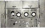
 |
| Above and below: Two views of the Ops building,
(DND file photos) |
 |
OPERATIONS IN THE MID 1960's
The unclassified document titled "Supplementary Radio Activities Consolidation
Plan dated May 30, 1966, provides some hints as to the activities in Inuvik
in the mid 1960's.
There was mention of wideband and narrowband positions at the station.
Ray White provides some insight. "In the early 1960's, receivers were developed
that could receive several mHz of spectrum and the output could be recorded
for playback at a later time. The idea was that a number of such wideband
positions could copy large pieces of the spectrum and the tapes could be
sent to a central location for processing. Those tapes could be played
back into banks of receivers and operators could copy the assigned signals.
Over the years this technology was improved to the point that most of the
personnel required to operate the station could be diverted to other functions.
Thus, the high cost of keeping large numbers of radio operators in an expensive
environment could be used to perform other jobs. The narrowband positions
were operated by a single operator tuning to assigned frequencies and copying
specific targets, usually items that required timely reporting to Ottawa.
This material would be analyzed on site and the end product reported electronically".
John Bennet provides a glimpse into direction finding activities. "We
used line bearings to help identify (locating) new transmissions
and as an aid to identifying specific targets. I remember that we
copied specific targets that changed their call signs every 6 hours.
These nets might consist of up to 10 or 15 outstations. We knew where the
outstations were located so a line bearing on a new call sign in the net
would let us know quickly just who the specific outstation was using that
call. It also helped when tracking mobile targets (aircraft) across
the north of Russia".
By 1966, Inuvik became more "operationally" important than Churchill,
Manitoba. There were two major reasons for this. First, the station was
becoming increasingly polluted with man-made noise as a result of population
encroachment. Secondly, with its more southerly latitude (approximately
58°N), it was considerably more distant from potential targets than
Inuvik or Alert. The consolidation plan called for the closure of HMCS
Churchill so the station closed it doors in 1968
The construction of additional administration and accommodation space
( including 42 PMQ), was intended to provide for the more personnel
to man more positions. The estimated cost of the additional administration
and accommodation space was expected to cost $840,000.
RADIO EQUIPMENT USED
This is a partial list of the equipment used at Inuvik. Additional details
provided below table.
(Click on image to enlarge)
 |
A Westinghouse MW transmitter was collocated
at the Department of Transport Transmitter Building which was near Inuvik
airport. The field around the transmitter building was covered in copper
wire but in spite of that it was very difficult to establish a good ground
due to the permafrost. Depicted here is a triple MW installation at
radio station WNU Slidell, Louisiana. Frequency range: 2 to 30 Mhz;
Power Output: 3000 watts.
Modes: A1 and F1; Frequency control: 3 crystal controlled positions;
Instruction Manual: CF-1933 (Photo courtesy WNU6) |
 |
Racal RA-17 Receiver.
Coverage
- Tuning range is 0.5 to 30 mHz in thirty 1 mHz bands. (Photo courtesy
David Knight, G3YNH) |
 |
AN/GRD-501. Eric Earl, KG4OZO, now
living in Atlanta, Georgia was a former CS rate and he confirms the presence
of the GRD-501 HFDF set while serving at Inuvik between the spring of 1969
and the spring of 1969. Eric remarks "For some reason, the GRD-501 position
was not manned in Inuvik and I only recall a couple of instances of use.
The GRD was located in the LRTS section of Ops. I, for one,
did use it a couple of times to get bearings on intruders in the 20 meter
ham band. This was contrary to regulations and I might have been disciplined
over it had anyone found out". John Bennett who served at Inuvik
from 1963-1965 also confirms the presence of the GRD-501 at that time.
(Photo
courtesy RCN) |
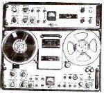 |
AFSAV-75A Tape Recorder Deck: A reel-to-reel
recorder/reproducer employing normal half-track operation. When using the
Applique unit, both channels could be used simultaneously. Recording was
a done at 3.75 inches per second only. One useful function on this recorder
was the ability to adjust the playback speed by about +/- 20%. (RCN
photo courtesy Doug Stewart) |
 |
AFSAV-75A Tape Recorder Amplifier:
When mounded in the deck, would face towards the rear. It had two
inputs: 1) A line input for recording from a receiver 2) A microphone
input with a separate volume control which could be used for logging or
overriding the other input.
Available accessories included a remote control unit and a footswitch.
Tube lineup consisted of 1 each: 6072A, 5751, 6201, 5814, 6AQ5W.
(Photo via E-bay, Germany) |
THE LOG PERIODIC ANTENNA
 SPECIFICATIONS: SPECIFICATIONS:
Model: Collins 237-A1
Frequency Range: 6.5 mHz to 60 mHz
Input Impedance: 52 ohm
Power Handling : 25 kw average; 50 kw peak
Dimensions: Longest element is 70 feet.
Boom Length: 52. feet
Gain: 8db over isotropic
VSWR: 2 to 1 over the entire frequency range
Wind and Ice Loading: 80 mph with 1/4" radial ice
Circa: 1959
(Photo by Collins Radio Company) |
| In communications, a log-periodic antenna (LP) is a broadband, multi
element, unidirectional, narrow-beam antenna that has impedance and radiation
characteristics that are regularly repetitive as a logarithmic function
of the excitation frequency. The individual components are often dipoles,
as in a log-periodic dipole array (LPDA). The length and spacing of the
elements of a log-periodic antenna increase logarithmically from one end
to the other. At Inuvik, the LPDA was located to the south and slightly
east of the Ops Building. |
According to Eric Earle, he remembers a vertically polarized rhombic
and several horizontal rhombics to the East and Northeast of the Ops Building.
Inuvik had at least one Beverage-like antenna that extended a very long
distance and was not supported above ground. It was just laid on the ground
and extended about a mile or so over some pretty rough terrain. Since the
ground is frozen for most of the year, there was no interaction between
the earth and the wire. It was a superb antenna for both LF and VLF operation.
Terminated in much the same way as a normal Beverage, the only basic difference
was its placement on the ground for the entire span. This idea originated
from the National Research Council and it worked because the real earth
ground was several thousand feet down below the permafrost.
Inuvik also has some VHF capability.
CRYPTO
Throughout the SUPRAD system, the ECM machine was the main cryptosystem
for Operational traffic, ie, messages pertaining to equipment, assignments,
etc.
Administrative traffic was processed on the Adonis
KL-7 system. That included traffic pertaining to personnel, accommodation,
etc and any matter that was considered too sensitive to be handled in an
unclassified manner. This included promotions (in the 1950's), drafts
(postings), discipline and training of CS personnel.
Stations whose operational load required an extremely large amount of
traffic, (Coverdale, Churchill and Aklavik/Inuvik) used Rockex
in the 1950's. When newer systems became available, the KW-26
was introduced for general useage throughout the RCN as a point-to-point
cryptosystem. Additionally, in the SUPRAD system, it employed special channels
for operational use. Traffic passed on the SUPRAD KW-26 links did not use
the same keying material (ie, the same one-time IBM-type cards) as the
RCN general communication channels.
For HFDF operations, the KWT-37
was used for Net Control Stations, such as Coverdale and Gander and the
KWR-37
(for the HFDF stations).
KW-7
was used for the outstations reporting circuits.
AMATEUR RADIO
After the move from Aklavik to Inuvik, there was a gap in amateur radio
operations. Call sign VE8AY, used at Aklavik, continued to appear in callbooks
with its Aklavik coordinates as late as 1963. No one knows why. Sometime
around the 1964-65 time period, VE8MK was procured as a club station
call sign. Its address was shown as: Inuvik Radio Club, P.O. Box 1352,
Inuvik. The 1963 callbook shows VE8MK as belonging to an individual in
Watson Lake. Access to VE8MK was strictly controlled. Anyone other
than a navy operator would need an invitation and would have to be signed
in and out of a special visitors book as well.
Eric Earle remembers HMCS Inuvik's Amateur Radio Club. "It was located
in the Mens Downtown Quarters. I do remember, shortly after having arrived
in Inuvik, Riggers from RCCS putting up a new tower for us with a 3 element
beam at the Mens Downtown Quarters. They were probably in town to install
a vertically polarized, fixed Log Periodic at the Operation site".
Harry Billard , currently holding call sign VE7JH, operated amateur
station VE8CB while he was stationed in Inuvik between 1971 and 1972.
This was not a club call sign but one he procured for himself in order
to run phone patches. He operated Collins type equipment into big beams
which he set up at his own expense. Because Harry procured a station licence,
this would suggest that VE8MK was no longer in use by that time frame.
There were no listings for VE8MK in the 1977 Callbook, a sure sign
it was retired. A 1983 Callbook listing shows VE8MK as belonging
to an individual in Pelly Bay. In 1987 it went to Tuktoyaktuk. The
Radio Amateurs Callsign database does not indicate any ownership
in August 2007.
CLOSURE
CFS Inuvik closed on 1 April 1986 and the site was transferred to the
Dept. of Transport for use as a telecommunications station. Nothing
remains of HMCS/CFS Inuvik today. Paul Komaromi, an Inuvik resident reports
that "the Town of Inuvik never really recovered after the base closure.
Even 20 years later, many people of all backgrounds still lament
its closing. The Navy Operations base at the end of Navy Road was completely
dismantled and removed. Whats left is simply the footprint.
At Operations, everything was removed including the ground wire arrays".
 |
This is a copy of the message which announced
the closure of Inuvik in 1986. Click on image to read message, |
TODAY
In 1954, the first survey teams flew to the Mackenzie Delta, looking
for the best site for the future, but unnamed town. A number of potential
sites were identified with this location being referred to as East Three.
The site was on a navigable river with access to wood, gravel, a
good, clean water supply and enough flat land for a major airport. Moreover,
the site had plenty of room for expansion and definitely no concerns about
flooding. The East Three site was selected and in hindsight, the choice
was a good one.
Inuvik now has a population of 3,200 as of 2000 and now
sports two radio stations. CHAK/860 is the CBC Radio One station (non-commercial)
and CKLB/101.9 is a 10 watt satellite station of CKLB Yellowknife, a community
station. Local languages are predominately Gwich'in, Inuvialuktun and English.
The community belongs to the electoral district of Mackenzie-Delta and
to the land claim area of Gwich'i.
(Click to enlarge)
 |
Inuvik Today (2000): The town has changed
substantially since 1961.
The circular road at the right which connects to a straight road going
north - the top of the picture is, in fact the Dempster Highway with
its connection to Tuktoyaktuk.The straight road, now called Highway 8 is
also known as Navy Road. It was named after the Royal Canadian Navy whose
personnel were amongst the original inhabitants of Inuvik. Lion Street,
one of the original streets, became part of Navy Road in the 1970's to
avoid confusion. (Photo courtesy of Municipal and Community Affairs
from the Inuvik Regional Health and Social Services Board Bulletin. Submitted
by Spud Roscoe). |
In May 2008, Jane Baryluk comments on the changes in Inuvik. "The
hold hospital is no longer there, being torn down in 2003. The new one
is built along the main road right below the old hospital in the 1961 photo.
There is now a parking lot where the old hospital stood. The staff residence
is still there and used for our transient professionals.
There are plans in the works to tear down the school and create a central
park of some sort. A new super school is in the planning stages now. Both
of the student hostels have been torn down years ago. The old Navy admin
building is all boarded up. After the military left it became a community
college for several years until a new building was erected. Everyone is
wondering what will become of that prime piece of property.
All those PMQs are still there along with several other houses. The
(Hudson's Bay Company) house we live in has not even been put on the lot
(in the inside crescent) yet in this photo. The town has grown significantly
since 1961 but in many ways it is still the same.
FOOTNOTES
[1] Many documents referred to the new site as Aklavik East-3.
In the Aklavik Journal newspaper (December 1956 and March 1957) the usage
was always "East 3", or "E3".
QUESTION
1) What model of Pusher antenna was used at Inuvik? Was it the British
Plessey AN/FRD-13? Contact: jerry.proc@sympatico.ca
Contributors and References:
1) Ray White e-mail: <legerwhite(at)gmail.com>
2) Spud Roscoe e-mail: <spudroscoe(at)eastlink.ca>
3) Gerald T. Burton e-mail: <acagerry(at)sympatico.ca>
4) Canadian Warship Names. David Freeman. Vanwell Publishing,
St. Catharines, Ont.
5) Bruce Forsyth's Canadian Military History Page
http://www.geocities.com/Pentagon/Quarters/2529/
6) SUPRAD Consolidation Plan. May 1966. http://watserv1.uwaterloo.ca/~brobinso/srsmay66.html
7) Inuvik Encyclopedia http://www.encyclopedia.com/html/I/Inuvik-twn.asp
8) DND Web site http://www.img.forces.gc.ca/commelec/brhistory/mar_e.htm
9) CBC Life and Times series. http://www.cbc.ca/lifeandtimes/cournoyea.html
10) NWT&Y Web page. http://www.nwtandy.rcsigs.ca/1923_29.htm
11) Communications and Electronics Museum. http://www.c-and-e-museum.org/
12) Joe Costello's RC Sigs Miltaria Page.
http://www.rcsigs.ca/ViewPage/History/Canadian-CESM-History/Page/7/
13) MW transmitter photo . http://www.coastalradio.greater-peterborough.com/wnu6.jpg
14) John Murison : <jolomurison(at)sympatico.ca>
15) Collins Collectors Association http://www.collinsradio.org/Collins_1959_HF-VHF_Ground.pdf
16) Inuvik Regional Heath and Service Board Bulletin.
17) HMCS badge image courtesy Ready Aye Ready web page.
http://www.readyayeready.com/badges/i.htm
18) CFS badge image courtesy Naval Security Web page.
http://www.anzwers.org/free/navyscpo/inuvik_big.jpg
19) Eric Earl, KG4OZO <eearle52(at)COMCAST.net>
20) John Bennett <djben(at)shaw.ca>
21) David Warmington <davidwarmington(at)rogers.com>
22) Paul Komaromi <komar(at)newnorth.ca>
23) Harry Billard VE7JH , <ve7jh(at)shaw.ca>
24) History of Canadian Signals Intelligence and Direction
Finding by Lynn Wortman and George Fraser.
25) Hartebeesthoek Radio Astronomy Observatory http://www.hartrao.ac.za/geodesy/BW271.jpg
26) Gary Westhouse VE3NIT. VE3 QSL manager . <g.westhouse(at)sympatico.ca>
27) Jane Baryluk <Jane_Baryluk(at)gov.nt.ca>
28) Gary King 46214-H RCN 1959-1968
<jgking(at)sympatico.ca>
29) Inuvik folder https://drive.google.com/drive/folders/17PrbLpoSdxEl5EHlsVBtE_ueYHgj47NH?usp=sharing
Back to Table of Contents
Sept 23/21


